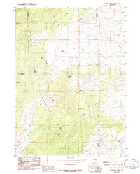
1985 Map of Harris Park
USGS Topo · Published 1985About this map
Harris Park and the surrounding high country of the Medicine Bow National Forest dominate this mid-1980s survey of the Laramie Mountains. The landscape is defined by a dense network of drainage systems, including Crow Creek, Mc Cune Creek, and Matilda Creek, which carve through the elevations marked by Albany Peak and Baldy Knob. This quadrangle illustrates a transition between the open parks of the high plateau and the sharper relief of peaks like Rock Mountain and Black Mountain.
Find a feature on this map
27 named features on this map. Tap any name to fly to it.
Don’t see what you’re looking for? This feature index may not catch every label — zoom into the map to look around manually.
Map Details
Editions of this 1985 Harris Park Map
This is the sole edition of this map. No revisions or reprints were ever made.
Other maps of this area

1943 · Esterbrook
USGS Topo · 1:62,500

1945 · Esterbrook
USGS Topo · 1:62,500

1949 · Spring Creek
USGS Topo · 1:24,000

1950 · Spring Creek
USGS Topo · 1:24,000

1950 · Cottonwood Falls
USGS Topo · 1:24,000

1951 · Cottonwood Falls
USGS Topo · 1:24,000

1953 · Johnson Mountain
USGS Topo · 1:24,000

1954 · Torrington
USGS Topo · 1:250,000

1958 · Torrington
USGS Topo · 1:250,000
1968 · Fletcher Park
USGS Topo · 1:24,000