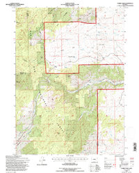
1992 Map of Harris Park
USGS Topo · Published 1996About this map
Harris Park and the high-elevation residential cluster of Harmon Heights sit within the eastern reaches of the Medicine Bow National Forest, illustrating the intersection of private inholdings and public timberland in the early 1990s. This survey, revised from earlier aerial photography, captures a landscape defined by significant topographical landmarks such as Albany Peak and Baldy Knob. The drainage network is particularly dense here, featuring the headwaters and winding paths of Cottonwood Creek, Horse Creek, and Matilda Creek. A network of 4wd routes and trails provides the primary access through the foothills and higher elevations, including named geological features like Point of Rocks and Little Point of Rocks. The map also clearly delineates the administrative boundaries where Albany County meets both Converse and Platte counties, reflecting the complex land management of the Laramie Range.
Find a feature on this map
23 named features on this map. Tap any name to fly to it.
Don’t see what you’re looking for? This feature index may not catch every label — zoom into the map to look around manually.
Map Details
Editions of this 1992 Harris Park Map
This is the sole edition of this map. No revisions or reprints were ever made.
Other maps of this area

1943 · Esterbrook
USGS Topo · 1:62,500

1945 · Esterbrook
USGS Topo · 1:62,500

1949 · Spring Creek
USGS Topo · 1:24,000

1950 · Spring Creek
USGS Topo · 1:24,000

1950 · Cottonwood Falls
USGS Topo · 1:24,000

1951 · Cottonwood Falls
USGS Topo · 1:24,000

1953 · Johnson Mountain
USGS Topo · 1:24,000

1954 · Torrington
USGS Topo · 1:250,000

1958 · Torrington
USGS Topo · 1:250,000
1968 · Fletcher Park
USGS Topo · 1:24,000