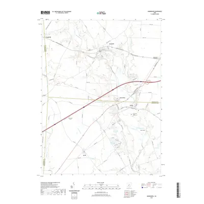
2019 Map of Harrisburg
USGS Topo · Published 2019About this map
Big Darby Creek meanders through this portion of central Ohio, marking a landscape defined by its riparian corridors and small agricultural communities at the edge of the Columbus metropolitan area. The village of Orient and the town of Harrisburg serve as local hubs, situated near the intersection of several historic thoroughfares like the Harrisburg Pike and London-Groveport Rd. A unique institutional presence is noted by the Orient Feeble Minded Institute Cem, providing a significant point of reference for genealogists and local historians researching the history of state-run facilities in Pickaway County.
Find a feature on this map
81 named features on this map. Tap any name to fly to it.
Don’t see what you’re looking for? This feature index may not catch every label — zoom into the map to look around manually.
Map Details
Editions of this 2019 Harrisburg Map
This is the sole edition of this map. No revisions or reprints were ever made.
Other maps of this area

1906 · Mt Sterling
USGS Topo · 1:62,500

1907 · London
USGS Topo · 1:62,500

1911 · Era
USGS Topo · 1:62,500

1913 · Era
USGS Topo · 1:62,500

1923 · West Columbus
USGS Topo · 1:62,500

1925 · West Columbus
USGS Topo · 1:62,500

1943 · Era
USGS Topo · 1:62,500

1947 · Columbus
USGS Topo · 1:250,000

1955 · Harrisburg
USGS Topo · 1:24,000
1955 · Commercial Point
USGS Topo · 1:24,000