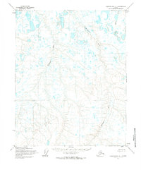
1955 Map of Harrison Bay A-1
USGS Topo · Published 1984About this map
Meandering arctic waterways dominate this 1955 survey of Alaska's North Slope, where the Kachemach River and Miluveach River wind across a landscape defined by thermokarst lakes and tundra. The hydrology of the region is further characterized by the presence of Kalubik Creek in the northeastern corner of the quadrangle. Mapping by the Army Map Service at this time relied on aerial photography to document a territory largely devoid of permanent settlements or infrastructure. The topographical patterns shown here—predating the major industrial expansion of the Prudhoe Bay era—illustrate a pristine drainage network of the Umiat Meridian, where the land lines were predetermined by the Bureau of Land Management but remained unsurveyed and unmarked on the ground.
Find a feature on this map
3 named features on this map. Tap any name to fly to it.
Don’t see what you’re looking for? This feature index may not catch every label — zoom into the map to look around manually.
Map Details
Editions of this 1955 Harrison Bay A-1 Map
2 editions found
Other maps of this area

1951 · Harrison Bay
USGS Topo · 1:250,000

1951 · Beechey Point
USGS Topo · 1:250,000

1951 · Sagavanirktok D-5
USGS Topo · 1:250,000

1952 · Umiat
USGS Topo · 1:250,000

1955 · Harrison Bay
USGS Topo · 1:250,000

1955 · Beechey Point
USGS Topo · 1:250,000

1955 · Harrison Bay B-2
USGS Topo · 1:63,360

1955 · Harrison Bay B-1
USGS Topo · 1:63,360

1955 · Beechey Point A-5
USGS Topo · 1:63,360

1955 · Umiat D-2
USGS Topo · 1:63,360