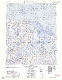
1962 Map of Harrison Bay B-3
USGS Topo · Published 1962About this map
Naval Petroleum Reserve No 4 dominates this landscape of the North Slope, where the intricate hydrology of the Arctic coastal plain meets the Beaufort Sea. The terrain is characterized by a dense network of lakes and meandering waterways, including the Fish Creek and the Ublutuoch River, which flow northward toward the shallow waters of Harrison Bay. A solitary Winter Trail cuts across the tundra, indicating the seasonal nature of transportation and resource exploration in this remote region during the late 1950s. The map captures a transition point in the Arctic, where federal land designations and the natural flow of the Kiyaktuakoch River define the boundary between industrial interest and the raw Alaskan wilderness.
Find a feature on this map
6 named features on this map. Tap any name to fly to it.
Don’t see what you’re looking for? This feature index may not catch every label — zoom into the map to look around manually.
Map Details
Editions of this 1962 Harrison Bay B-3 Map
This is the sole edition of this map. No revisions or reprints were ever made.
Other maps of this area

1951 · Harrison Bay
USGS Topo · 1:250,000

1955 · Harrison Bay
USGS Topo · 1:250,000

1955 · Harrison Bay A-4
USGS Topo · 1:63,360

1955 · Harrison Bay B-3
USGS Topo · 1:63,360
1955 · Harrison Bay C-3
USGS Topo · 1:63,360

1955 · Harrison Bay B-2
USGS Topo · 1:63,360

1955 · Harrison Bay A-2
USGS Topo · 1:63,360

1955 · Harrison Bay A-3
USGS Topo · 1:63,360

1955 · Harrison Bay C-4
USGS Topo · 1:63,360

1955 · Harrison Bay B-4
USGS Topo · 1:63,360