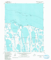
1955 Map of Harrison Bay D-5
USGS Topo · Published 1992About this map
Esook Trading Post stands as a solitary human marker on this mid-century survey of the Arctic coastline. Located on the edge of Pogik Bay, the post served as a vital hub for trade and communication in a landscape dominated by the interconnected lagoons and low-lying marshes of the National Petroleum Reserve in Alaska. The terrain is defined by its transition from the shallow waters of the Beaufort Sea to a coastal plain saturated with unnamed lakes and ponds, illustrating the complex hydrology of the North Slope. Early industrial interest in the region's sub-surface resources is evidenced by the presence of Cape Halkett No 1 Well in the southeastern portion of the quadrangle. Geographic markers such as Pogik Point and Cameron Point delineate the irregular shoreline, providing essential navigation points for maritime travel along the continental slope before the era of modern development.
Find a feature on this map
8 named features on this map. Tap any name to fly to it.
Don’t see what you’re looking for? This feature index may not catch every label — zoom into the map to look around manually.
Map Details
Editions of this 1955 Harrison Bay D-5 Map
3 editions found
Other maps of this area

1951 · Harrison Bay
USGS Topo · 1:250,000

1951 · Teshekpuk
USGS Topo · 1:250,000

1955 · Harrison Bay
USGS Topo · 1:250,000

1955 · Teshekpuk
USGS Topo · 1:250,000

1955 · Harrison Bay D-4
USGS Topo · 1:63,360

1955 · Harrison Bay C-5
USGS Topo · 1:63,360

1955 · Harrison Bay D-5
USGS Topo · 1:63,360

1955 · Teshekpuk D-1
USGS Topo · 1:63,360

1955 · Harrison Bay C-4
USGS Topo · 1:63,360
1955 · Teshekpuk C-1
USGS Topo · 1:63,360