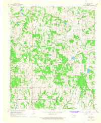
1967 Map of Hart
USGS Topo · Published 1968About this map
Sandy Creek and its numerous tributaries dominate this Garvin County landscape, which transitions between the Walker and Midland districts. The small settlement of Hart serves as a local focal point, supported by the nearby Hart Cem and the Prairie View Mission to the southwest. This mid-1960s topography reveals a landscape defined by both natural watercourses and human industry, evidenced by the scattered Oil Wells, Gravel Pits, and Sandpits that dot the creek valleys. To the south, the community of Dolberg sits near Hogskin Creek and Rock Creek, illustrating the dispersed settlement patterns typical of this region. The map also captures several family-named landmarks and civil boundaries, including the intersections of Garvin, Pontotoc, and Murray Counties, which are essential for genealogists tracing local property and residency records.
Find a feature on this map
30 named features on this map. Tap any name to fly to it.
Don’t see what you’re looking for? This feature index may not catch every label — zoom into the map to look around manually.
Map Details
Editions of this 1967 Hart Map
2 editions found
Other maps of this area

1898 · Pauls Valley
USGS Topo · 1:125,000

1901 · Stonewall
USGS Topo · 1:125,000

1902 · Pauls Valley
USGS Topo · 1:125,000

1957 · Ardmore
USGS Topo · 1:250,000

1963 · Ardmore
USGS Topo · 1:250,000

1964 · Byars
USGS Topo · 1:24,000

1965 · Pauls Valley NE
USGS Topo · 1:24,000

1965 · Davis
USGS Topo · 1:24,000

1967 · Roff South
USGS Topo · 1:24,000
1967 · Vanoss
USGS Topo · 1:24,000