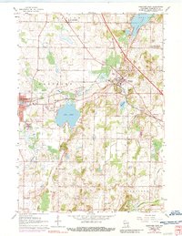
1959 Map of Hartford East
USGS Topo · Published 1989About this map
Slinger sits at a major rail junction where the Chicago Milwaukee St Paul and Pacific tracks intersect the Pacific RR, shaping the development of this corner of Washington County. This survey shows the expansion of Hartford to the west and the rural hamlets of St Lawrence and Ackerville. The landscape is defined by its glacial hydrology, with the large expanse of Pike Lake and the smaller Cedar Lake providing recreational anchors, including the Pike Lake State Park and various campgrounds. For family historians, the map identifies several rural institutions such as St Pauls Church and St Augustine School. Extensive gravel operations are visible throughout the townships of Hartford and Polk, reflecting the local industrial extraction of glacial deposits that defined the mid-century economy.
Find a feature on this map
47 named features on this map. Tap any name to fly to it.
Don’t see what you’re looking for? This feature index may not catch every label — zoom into the map to look around manually.
Map Details
Editions of this 1959 Hartford East Map
3 editions found
Other maps of this area

1892 · Waukesha
USGS Topo · 1:62,500

1892 · Oconomowoc
USGS Topo · 1:62,500

1901 · Waukesha
USGS Topo · 1:62,500

1904 · West Bend
USGS Topo · 1:62,500

1904 · Hartford
USGS Topo · 1:62,500

1906 · Waukesha
USGS Topo · 1:62,500

1909 · Oconomowoc
USGS Topo · 1:62,500

1957 · Madison
USGS Topo · 1:250,000

1959 · West Bend
USGS Topo · 1:62,500
1959 · Stonebank
USGS Topo · 1:24,000