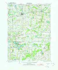
1927 Map of Hartford
USGS Topo · Published 1967About this map
Hartford serves as the primary rail hub of this 1927 survey, situated at the intersection of the Pere Marquette railroad and U S Highway No 12. The landscape is defined by its extensive lake systems, particularly the recreational areas around Sister Lakes and Magician Lake, which show early residential and leisure development at Woodland Beach and Sandy Beach. Beyond the lakeside settlements, the region is dotted with numerous small district schools such as Stickney Sch, Barnes Sch, and Keeler Sch, reflecting a dense rural population before the consolidation of the late 20th century.
Find a feature on this map
107 named features on this map. Tap any name to fly to it.
Don’t see what you’re looking for? This feature index may not catch every label — zoom into the map to look around manually.
Map Details
Editions of this 1927 Hartford Map
3 editions found
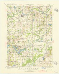
Other maps of this area

1927 · Niles
USGS Topo · 1:62,500

1927 · Hartford
USGS Topo · 1:62,500

1927 · Bangor
USGS Topo · 1:62,500

1927 · Benton Harbor
USGS Topo · 1:62,500

1927 · South Haven
USGS Topo · 1:62,500

1930 · South Haven
USGS Topo · 1:62,500

1930 · Benton Harbor
USGS Topo · 1:62,500

1930 · Niles
USGS Topo · 1:62,500

1931 · Bangor
USGS Topo · 1:62,500

1931 · Hartford
USGS Topo · 1:62,500