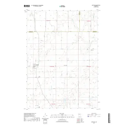
2019 Map of Hartland
USGS Topo · Published 2019About this map
Hartland and Bath anchor this landscape at the intersection of Freeborn, Waseca, and Steele Counties in southern Minnesota. The terrain is defined by the winding course of the Le Sueur River and numerous agricultural drainage systems like County Ditch Number Fortysix. A significant geological feature, the Mule Lakebed, provides insight into the region's post-glacial drainage patterns and land use history. Genealogists will find several burial sites preserved here, including Saint Aldens Cem near Bath and the West Freeborn Cem in the southwestern section. The map illustrates a highly organized rural grid of township roads such as 685th Ave and 300th St, which trace the boundaries of long-established farmsteads across the fertile prairie.
Find a feature on this map
48 named features on this map. Tap any name to fly to it.
Don’t see what you’re looking for? This feature index may not catch every label — zoom into the map to look around manually.
Map Details
Editions of this 2019 Hartland Map
This is the sole edition of this map. No revisions or reprints were ever made.
Other maps of this area

1954 · Albert Lea
USGS Topo · 1:62,500

1954 · Mason City
USGS Topo · 1:250,000

1955 · Wells
USGS Topo · 1:62,500

1957 · Mason City
USGS Topo · 1:250,000

1958 · Mason City
USGS Topo · 1:250,000

1967 · Freeborn
USGS Topo · 1:24,000
1967 · Otisco
USGS Topo · 1:24,000
1967 · Hope
USGS Topo · 1:24,000

1967 · Hartland
USGS Topo · 1:24,000

1967 · Ellendale
USGS Topo · 1:24,000