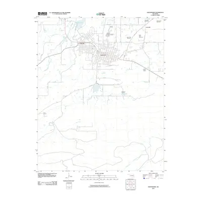
2010 Map of Hartshorne
USGS Topo · Published 2010About this map
Hartshorne and Haileyville form a dense grid of residential and commercial development in this corner of Pittsburg County. The landscape is defined by the sharp rise of prominent ridges, including the appropriately named Number Ten Mountain and the distinctively titled Belle Starr Mountain. To the north, Dow Lake and Brushy Creek drain toward the urban centers, while the southern reaches of the sheet are marked by the extensive waters of Hartshorne Lake behind the Hartshorne Lake Dam. Local history is preserved in a concentration of burial sites on the northern edge of town, where Elm Park Cemetery, Elmwood Cemetery, and Holy Rosary Cemetery sit in close proximity. The infrastructure of the era is evident in the transition from the city streets of Hartshorne to the rural roads like Savage Hwy and Dianna Blvd, and the presence of the Flying A Ranch Airport to the east.
Find a feature on this map
31 named features on this map. Tap any name to fly to it.
Don’t see what you’re looking for? This feature index may not catch every label — zoom into the map to look around manually.
Map Details
Editions of this 2010 Hartshorne Map
This is the sole edition of this map. No revisions or reprints were ever made.
Other maps of this area

1898 · McAlester
USGS Topo · 1:125,000

1901 · Tuskahoma
USGS Topo · 1:125,000

1908 · Tuskahoma
USGS Topo · 1:125,000

1909 · Mc Alester
USGS Topo · 1:125,000

1909 · Tuskahoma
USGS Topo · 1:125,000

1950 · Mcalester
USGS Topo · 1:250,000

1962 · McAlester
USGS Topo · 1:250,000

1965 · McAlester
USGS Topo · 1:250,000

1967 · Krebs
USGS Topo · 1:24,000
1967 · Adamson
USGS Topo · 1:24,000