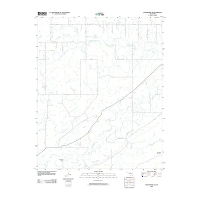
2009 Map of Hartshorne SW
USGS Topo · Published 2009About this map
Brushy Indian Baptist Cemetery serves as a significant genealogical landmark in this section of southeastern Oklahoma, situated near the southern banks of Brushy Creek. The landscape is defined by a dense network of tributaries, including Peaceable Creek, Gardner Creek, and Wolf Creek, which create a complex drainage pattern across the region. In the southeast corner, the elevation rises toward New State Mountain, a prominent terrain feature that contrasts with the creek-fed lowlands. The rural road system follows a grid-like pattern typical of mid-continent development, with routes like Peaceable Rd, Bache Rd, and High Hill Rd connecting dispersed homesteads and providing access to these vital water sources. This 2009 survey reflects the enduring rural character of Pittsburg County, where the interaction between small-scale agriculture and the rugged geography of the Choctaw Nation territory remains evident.
Find a feature on this map
37 named features on this map. Tap any name to fly to it.
Don’t see what you’re looking for? This feature index may not catch every label — zoom into the map to look around manually.
Map Details
Editions of this 2009 Hartshorne SW Map
This is the sole edition of this map. No revisions or reprints were ever made.
Other maps of this area

1898 · McAlester
USGS Topo · 1:125,000

1909 · Mc Alester
USGS Topo · 1:125,000

1950 · Mcalester
USGS Topo · 1:250,000

1962 · McAlester
USGS Topo · 1:250,000

1965 · McAlester
USGS Topo · 1:250,000

1967 · Pittsburg
USGS Topo · 1:24,000

1967 · Krebs
USGS Topo · 1:24,000
1967 · Mc Alester
USGS Topo · 1:24,000
1967 · Adamson
USGS Topo · 1:24,000

1967 · Hartshorne SW
USGS Topo · 1:24,000