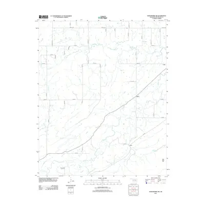
2012 Map of Hartshorne SW
USGS Topo · Published 2012About this map
Brushy Indian Baptist Cem and the surrounding valley of Brushy Creek anchor this rural landscape in the southeastern corner of Oklahoma. The terrain is defined by a dense network of waterways including Peaceable Creek, Miller Creek, and Gardner Creek, which snake through the timbered hills of New State Mountain. Small communities like Bond and Arch serve as local crossroads, connected by a grid of county roads such as High Hill Road and Bache Road. The settlement pattern reflects the area's agricultural and ranching heritage, with homesteads clustered along the fertile creek bottoms. In the northeast, Craig marks a point of transition toward the larger regional centers. This survey provides a precise look at the 2012 topography before more recent infrastructure developments, preserving the location of family-named landmarks and historical cemeteries that are vital for local genealogy research.
Find a feature on this map
44 named features on this map. Tap any name to fly to it.
Don’t see what you’re looking for? This feature index may not catch every label — zoom into the map to look around manually.
Map Details
Editions of this 2012 Hartshorne SW Map
This is the sole edition of this map. No revisions or reprints were ever made.
Other maps of this area

1898 · McAlester
USGS Topo · 1:125,000

1909 · Mc Alester
USGS Topo · 1:125,000

1950 · Mcalester
USGS Topo · 1:250,000

1962 · McAlester
USGS Topo · 1:250,000

1965 · McAlester
USGS Topo · 1:250,000

1967 · Pittsburg
USGS Topo · 1:24,000

1967 · Krebs
USGS Topo · 1:24,000
1967 · Mc Alester
USGS Topo · 1:24,000
1967 · Adamson
USGS Topo · 1:24,000

1967 · Hartshorne SW
USGS Topo · 1:24,000