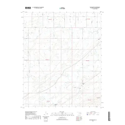
2018 Map of Hartshorne SW
USGS Topo · Published 2018About this map
Limestone Ridge and New State Mtn dominate the topography of this corner of Pittsburg County, dictating the drainage of numerous small waterways. In the late 2010s, the rural character of the area remains evident, defined by a sparse network of section-line roads like Four Corners Rd and Anderson Rd. The small settlements of Arch and Craig serve as local anchors in a landscape otherwise composed of creek bottomlands and ridges. Significant water features such as Peaceable Creek and Brushy Creek wind through the terrain, while the Lime Arch Bridge provides a notable landmark in the southern reaches. This survey offers a detailed view of the rural infrastructure and natural hydrology before further modern development, capturing the specific alignment of local routes and the boundaries of townships from t5n r15e to t3n r16e.
Find a feature on this map
36 named features on this map. Tap any name to fly to it.
Don’t see what you’re looking for? This feature index may not catch every label — zoom into the map to look around manually.
Map Details
Editions of this 2018 Hartshorne SW Map
This is the sole edition of this map. No revisions or reprints were ever made.
Other maps of this area

1898 · McAlester
USGS Topo · 1:125,000

1909 · Mc Alester
USGS Topo · 1:125,000

1950 · Mcalester
USGS Topo · 1:250,000

1962 · McAlester
USGS Topo · 1:250,000

1965 · McAlester
USGS Topo · 1:250,000

1967 · Pittsburg
USGS Topo · 1:24,000

1967 · Krebs
USGS Topo · 1:24,000
1967 · Mc Alester
USGS Topo · 1:24,000
1967 · Adamson
USGS Topo · 1:24,000

1967 · Hartshorne SW
USGS Topo · 1:24,000