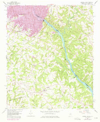
1959 Map of Hartwell Dam
USGS Topo · Published 1975About this map
The Savannah River defines the border between Georgia and South Carolina, anchoring this landscape during the mid-century creation of Lake Hartwell. The completion of the Hartwell Dam transformed the local geography, inundating valleys once drained by Generostee Creek and Cedar Creek. While the newly formed lake dominates the northwest, the southern portion of the map remains a rural landscape of ridges and creeks, centered around the settlement of Montevideo. Numerous country churches and burial grounds, such as Beulah Cem Ch and Cokesbury Ch, are scattered throughout the hills, providing valuable landmarks for family history research. This map captures the region in transition as it moved from a strictly riverine and agricultural economy to one shaped by large-scale hydroelectric development and recreation, while preserving the footprints of older communities like Sardis Ch and Flat Rock Ch.
Find a feature on this map
35 named features on this map. Tap any name to fly to it.
Don’t see what you’re looking for? This feature index may not catch every label — zoom into the map to look around manually.
Map Details
Editions of this 1959 Hartwell Dam Map
4 editions found
Other maps of this area

1893 · Elberton
USGS Topo · 1:125,000

1954 · Greenville
USGS Topo · 1:250,000

1958 · Greenville
USGS Topo · 1:250,000

1958 · Elberton
USGS Topo · 1:62,500

1959 · Hartwell Dam
USGS Topo · 1:24,000

1959 · Hartwell NE
USGS Topo · 1:24,000

1959 · Hartwell
USGS Topo · 1:24,000
1960 · Reed Creek
USGS Topo · 1:24,000

1964 · Iva
USGS Topo · 1:24,000

1964 · Lowndesville
USGS Topo · 1:24,000