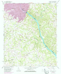
1959 Map of Hartwell Dam
USGS Topo · Published 1986About this map
The Hartwell Dam stands as the primary engineering marvel on this mid-century survey, anchoring the border where the Savannah River separates Hart County, Georgia, from South Carolina. While the massive reservoir of Hartwell Lake dominates the northwest, the map captures a rural landscape transitioning into the hydroelectric era. Local life is charted through numerous country congregations, including St James Ch, Beulah Ch, and Sardis Ch, alongside small settlements like Montevideo and Cokesbury. A network of creeks, such as Little Cedar Creek and Pickens Creek, drain the undulating terrain into the river valley. The presence of a Strip Mine and various island features like Derritt Island and Greens Island reflect the area's diverse industrial and natural character before the full impact of 1980s development was recorded during the map's photorevision.
Find a feature on this map
34 named features on this map. Tap any name to fly to it.
Don’t see what you’re looking for? This feature index may not catch every label — zoom into the map to look around manually.
Map Details
Editions of this 1959 Hartwell Dam Map
4 editions found
Other maps of this area

1893 · Elberton
USGS Topo · 1:125,000

1954 · Greenville
USGS Topo · 1:250,000

1958 · Greenville
USGS Topo · 1:250,000

1958 · Elberton
USGS Topo · 1:62,500

1959 · Hartwell Dam
USGS Topo · 1:24,000

1959 · Hartwell NE
USGS Topo · 1:24,000

1959 · Hartwell
USGS Topo · 1:24,000
1960 · Reed Creek
USGS Topo · 1:24,000

1964 · Iva
USGS Topo · 1:24,000

1964 · Lowndesville
USGS Topo · 1:24,000