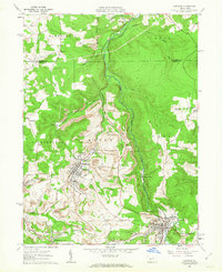
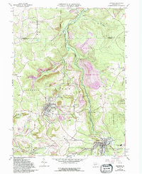
1961 Map of Hastings
USGS Topo · Published 1963About this map
The borough of Hastings and the surrounding coal-rich hills of Cambria County define this early 1960s landscape, where industrial activity and residential life are closely entwined. The terrain is marked by numerous Strip Mine operations that flank the winding course of Chest Creek and its many tributaries, such as Brubaker Run and Little Killbuck Run. Smaller settlements like Swedetown, Slickport, and St Boniface dot the hillsides, reflecting a densely settled rural pattern typical of Pennsylvania's bituminous coal region during this period.
Find a feature on this map
48 named features on this map. Tap any name to fly to it.
Don’t see what you’re looking for? This feature index may not catch every label — zoom into the map to look around manually.
Map Details
Editions of this 1961 Hastings Map
5 editions found
Other maps of this area

1902 · Patton
USGS Topo · 1:62,500

1902 · Barnesboro
USGS Topo · 1:62,500

1903 · Curwensville
USGS Topo · 1:62,500

1904 · Barnesboro
USGS Topo · 1:62,500

1904 · Patton
USGS Topo · 1:62,500

1906 · Punxsutawney
USGS Topo · 1:62,500

1939 · Curwensville
USGS Topo · 1:62,500

1939 · Punxsutawney
USGS Topo · 1:62,500

1942 · Curwensville
USGS Topo · 1:62,500

1942 · Punxsutawney
USGS Topo · 1:62,500