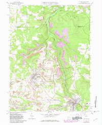
1961 Map of Hastings
USGS Topo · Published 1982About this map
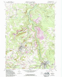
Chest Creek winds through the heart of this northern Cambria County landscape, where the local economy and geography were once defined by extensive coal operations. The terrain is marked by numerous Strip Mines and the visible remnants of former transportation networks, including sections of Old Railroad Grade and Old RR Grade. These corridors reflect a period when industry drove the development of small settlements like Hastings, Slickport, and Swedetown. Religious and community landmarks serve as genealogical anchors, notably St Josephs Ch and several burial grounds such as St Bernard Cem and Union Cem. To the east, the map transitions into the preserved territory of State Game Lands No 120, while the southern reaches show the developed streets of Patton near the Filtration Plant.
Find a feature on this map
53 named features on this map. Tap any name to fly to it.
Don’t see what you’re looking for? This feature index may not catch every label — zoom into the map to look around manually.
Map Details
Editions of this 1961 Hastings Map
5 editions found
Other maps of this area

1902 · Patton
USGS Topo · 1:62,500

1902 · Barnesboro
USGS Topo · 1:62,500

1903 · Curwensville
USGS Topo · 1:62,500

1904 · Barnesboro
USGS Topo · 1:62,500

1904 · Patton
USGS Topo · 1:62,500

1906 · Punxsutawney
USGS Topo · 1:62,500

1939 · Curwensville
USGS Topo · 1:62,500

1939 · Punxsutawney
USGS Topo · 1:62,500

1942 · Curwensville
USGS Topo · 1:62,500

1942 · Punxsutawney
USGS Topo · 1:62,500