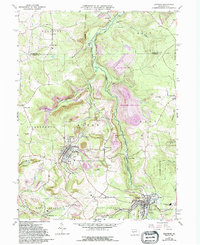
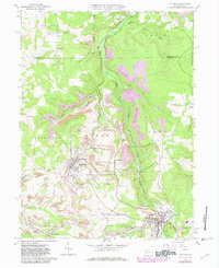
1961 Map of Hastings
USGS Topo · Published 1994About this map
Chest Creek carves a deep valley through the center of this landscape, separating the mining districts of Elder and Chest townships. The 1961 field data reveals a region defined by its industrial extraction, specifically the numerous Strip Mine operations and large expanses of reclaimed strip mine land that dominate the hillsides. Settlement patterns follow both the water and the extractive economy, with the borough of Hastings serving as a central hub. Evidence of the area's transit history is preserved through the Old Railroad Grade and Old RR Grade winding through the hollows.
Find a feature on this map
58 named features on this map. Tap any name to fly to it.
Don’t see what you’re looking for? This feature index may not catch every label — zoom into the map to look around manually.
Map Details
Editions of this 1961 Hastings Map
5 editions found
Other maps of this area

1902 · Patton
USGS Topo · 1:62,500

1902 · Barnesboro
USGS Topo · 1:62,500

1903 · Curwensville
USGS Topo · 1:62,500

1904 · Barnesboro
USGS Topo · 1:62,500

1904 · Patton
USGS Topo · 1:62,500

1906 · Punxsutawney
USGS Topo · 1:62,500

1939 · Curwensville
USGS Topo · 1:62,500

1939 · Punxsutawney
USGS Topo · 1:62,500

1942 · Curwensville
USGS Topo · 1:62,500

1942 · Punxsutawney
USGS Topo · 1:62,500