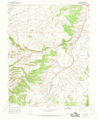
1966 Map of Hatch
USGS Topo · Published 1969About this map
The Hatch settlement and the older village of Hillsdale anchor this mid-1960s survey along the upper reaches of the Sevier River. The landscape is defined by the transition from the river valley floor to the high, wooded plateaus of the Dixie National Forest. Transportation and utility infrastructure of the era are clearly marked, including a local Substation and primitive Landing Strips situated just east of the river near Hatch.
Find a feature on this map
26 named features on this map. Tap any name to fly to it.
Don’t see what you’re looking for? This feature index may not catch every label — zoom into the map to look around manually.
Map Details
Editions of this 1966 Hatch Map
2 editions found
Other maps of this area

1886 · Kanab
USGS Topo · 1:250,000

1953 · Cedar City
USGS Topo · 1:250,000

1958 · Cedar City
USGS Topo · 1:250,000

1958 · Panguitch Lake
USGS Topo · 1:62,500

1962 · Cedar City
USGS Topo · 1:250,000

1966 · Wilson Peak
USGS Topo · 1:24,000

1966 · Hatch
USGS Topo · 1:24,000

1966 · George Mtn
USGS Topo · 1:24,000
1966 · Tropic Reservoir
USGS Topo · 1:24,000

1971 · Fivemile Ridge
USGS Topo · 1:24,000