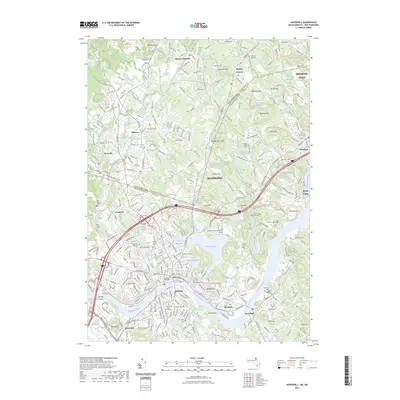
2023 Map of Haverhill
USGS Topo · Published 2023About this map
The Merrimack River bisects this landscape, separating the core of Haverhill and Bradford from the surrounding highlands and satellite settlements. Modern infrastructure and residential growth are visible throughout the region, though the map preserves the names of numerous historical burial grounds, such as the Hilldale Cem and the Old Town Hall Cem, which offer significant value for genealogical research. The rail corridor of the B & M RR still serves as a defining transit spine through Plaistow and Newton Junction, mirroring the river’s historical role in industrial development. Several distinct water bodies, including Lake Pentucket and Lake Saltonstall, remain central landmarks within the urbanized grid, while higher ground is marked by features like Ayers Hill and Brandy Brow Hill. This survey provides a clear view of the area's transition from traditional mill town centers to a more complex modern educational and residential hub, anchored by institutions like Northern Essex Community College.
Find a feature on this map
313 named features on this map. Tap any name to fly to it.
Don’t see what you’re looking for? This feature index may not catch every label — zoom into the map to look around manually.
Map Details
Editions of this 2023 Haverhill Map
This is the sole edition of this map. No revisions or reprints were ever made.
Other maps of this area

1886 · Lawrence
USGS Topo · 1:62,500

1888 · Newburyport
USGS Topo · 1:62,500

1888 · Haverhill
USGS Topo · 1:62,500

1888 · Lawrence
USGS Topo · 1:62,500

1888 · Salem
USGS Topo · 1:62,500

1890 · Haverhill
USGS Topo · 1:62,500

1890 · Newburyport
USGS Topo · 1:62,500

1893 · Salem
USGS Topo · 1:62,500

1893 · Lawrence
USGS Topo · 1:62,500

1893 · Haverhill
USGS Topo · 1:62,500