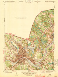
1943 Map of Haverhill
USGS Topo · Published 1943About this map
Haverhill and Bradford anchor this wartime landscape, positioned where the Merrimack River bends through Essex County. The map details a dense urban core of civic and educational institutions, from City Hall to Bradford Junior College. Public parks and natural landmarks like Winnekenni Park and the three major interior water bodies—Kenoza Lake, Lake Pentucket, and Lake Saltonstall—break the residential street grid. This survey highlights a significant concentration of local-history landmarks, including the Whittier Birthplace and the Hannah Duston Sch, alongside a dense network of early 20th-century neighborhood schools like Smiley Sch and Peabody Sch. Downstream, the character shifts toward more distinct settlements like Rocks Village and Groveland, while the northern hills toward the New Hampshire state line remain dominated by topographic features like Red Oak and Highlands Hill.
Find a feature on this map
86 named features on this map. Tap any name to fly to it.
Don’t see what you’re looking for? This feature index may not catch every label — zoom into the map to look around manually.
Map Details
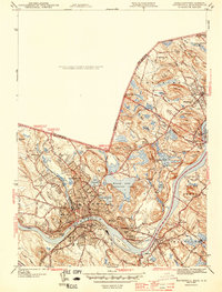
Editions of this 1943 Haverhill Map
2 editions found
Other maps of this area

1886 · Lawrence
USGS Topo · 1:62,500

1888 · Newburyport
USGS Topo · 1:62,500

1888 · Haverhill
USGS Topo · 1:62,500

1888 · Lawrence
USGS Topo · 1:62,500

1888 · Salem
USGS Topo · 1:62,500

1890 · Haverhill
USGS Topo · 1:62,500

1890 · Newburyport
USGS Topo · 1:62,500

1893 · Salem
USGS Topo · 1:62,500

1893 · Lawrence
USGS Topo · 1:62,500

1893 · Haverhill
USGS Topo · 1:62,500