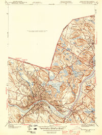
1943 Map of Haverhill
USGS Topo · Published 1943About this map
The Merrimack River serves as the dominant geographic spine for this 1940s Essex County landscape, separating the industrial and academic hub of Haverhill from the southern communities of Bradford and Groveland. The map highlights a dense concentration of educational and civic institutions, including the campus of Bradford Junior College and numerous neighborhood schools such as the Hannah Duston Sch and Smiley Sch. Cultural landmarks like the Whittier Birthplace sit near the border with Merrimac, while the recreational spaces of Winnekenni Park surround Kenoza Lake.
Find a feature on this map
101 named features on this map. Tap any name to fly to it.
Don’t see what you’re looking for? This feature index may not catch every label — zoom into the map to look around manually.
Map Details
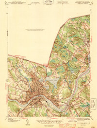
Editions of this 1943 Haverhill Map
2 editions found
Other maps of this area

1886 · Lawrence
USGS Topo · 1:62,500

1888 · Newburyport
USGS Topo · 1:62,500

1888 · Haverhill
USGS Topo · 1:62,500

1888 · Lawrence
USGS Topo · 1:62,500

1888 · Salem
USGS Topo · 1:62,500

1890 · Haverhill
USGS Topo · 1:62,500

1890 · Newburyport
USGS Topo · 1:62,500

1893 · Salem
USGS Topo · 1:62,500

1893 · Lawrence
USGS Topo · 1:62,500

1893 · Haverhill
USGS Topo · 1:62,500