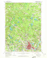
1956 Map of Haverhill
USGS Topo · Published 1972About this map
The Haverhill and Bradford riverfronts define this mid-century landscape along the Merrimack, where industrial centers meet the sprawling hills of the New Hampshire border. Significant institutional landmarks include the Bradford Peabody Jr College and the historic Whittier Birthplace east of the city center. The region's transport evolution is evident in the transition from traditional rail hubs like Fremont Station and Newton Junction to the development of the Merrimack Valley Golf Club and suburban expansions near Salem Depot.
Find a feature on this map
257 named features on this map. Tap any name to fly to it.
Don’t see what you’re looking for? This feature index may not catch every label — zoom into the map to look around manually.
Map Details
Editions of this 1956 Haverhill Map
3 editions found
Other maps of this area

1886 · Lawrence
USGS Topo · 1:62,500

1886 · Lowell
USGS Topo · 1:62,500

1888 · Newburyport
USGS Topo · 1:62,500

1888 · Haverhill
USGS Topo · 1:62,500

1888 · Lawrence
USGS Topo · 1:62,500

1888 · Salem
USGS Topo · 1:62,500

1890 · Haverhill
USGS Topo · 1:62,500

1890 · Newburyport
USGS Topo · 1:62,500

1893 · Lowell
USGS Topo · 1:62,500

1893 · Dover
USGS Topo · 1:62,500