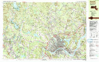
1987 Map of Haverhill
USGS Topo · Published 1987About this map
The Merrimack River serves as the dominant geographical feature of this 1980s landscape, winding past the urban centers of Haverhill and Groveland. The map captures the dense settlement patterns of the late 20th century, where older village cores like Ayers Village and Newton Junction are linked by a developing network of highways and the Boston and Maine Railroad. On the New Hampshire side of the border, the topography is punctuated by numerous family-named peaks such as Poors Hill and Bragg Hill, alongside recreational and educational hubs like Atkinson Academy and the Crystal Springs Golf Club.
Find a feature on this map
124 named features on this map. Tap any name to fly to it.
Don’t see what you’re looking for? This feature index may not catch every label — zoom into the map to look around manually.
Map Details
Editions of this 1987 Haverhill Map
2 editions found
Other maps of this area

1886 · Lawrence
USGS Topo · 1:62,500

1886 · Lowell
USGS Topo · 1:62,500

1888 · Newburyport
USGS Topo · 1:62,500

1888 · Haverhill
USGS Topo · 1:62,500

1888 · Lawrence
USGS Topo · 1:62,500

1888 · Salem
USGS Topo · 1:62,500

1890 · Haverhill
USGS Topo · 1:62,500

1890 · Newburyport
USGS Topo · 1:62,500

1893 · Lowell
USGS Topo · 1:62,500

1893 · Salem
USGS Topo · 1:62,500