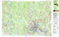
1987 Map of Haverhill
USGS Topo · Published 1987About this map
The Merrimack River snakes through the heart of this late-twentieth-century study, defining the southern boundary of Haverhill and Riverside. This urban and suburban landscape is heavily shaped by its historic transportation and water infrastructure, from the Boston and Maine Railroad cutting through Bradford to the expansive waters of Arlington Mill Reservoir and Canobie Lake. Genealogists will find a high density of burial sites including Linwood Cem, St Josephs Cem, and St Patricks Cem, alongside long-established institutions like the Atkinson Academy. The transition from Massachusetts into New Hampshire is marked by a shift from the dense streets of Haverhill toward the numerous lakeside groves and clustered settlements like Salem Depot, Atkinson Depot, and Howards Grove. Industrial activity is evident in the numerous Gravel Pits dotting the northern terrain near Plaistow.
Find a feature on this map
133 named features on this map. Tap any name to fly to it.
Don’t see what you’re looking for? This feature index may not catch every label — zoom into the map to look around manually.
Map Details
Editions of this 1987 Haverhill Map
2 editions found
Other maps of this area

1886 · Lawrence
USGS Topo · 1:62,500

1886 · Lowell
USGS Topo · 1:62,500

1888 · Newburyport
USGS Topo · 1:62,500

1888 · Haverhill
USGS Topo · 1:62,500

1888 · Lawrence
USGS Topo · 1:62,500

1888 · Salem
USGS Topo · 1:62,500

1890 · Haverhill
USGS Topo · 1:62,500

1890 · Newburyport
USGS Topo · 1:62,500

1893 · Lowell
USGS Topo · 1:62,500

1893 · Salem
USGS Topo · 1:62,500