
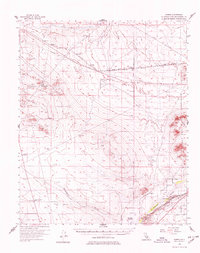
1956 Map of Hawes
USGS Topo · Published 1959About this map
The Atchison Topeka and Santa Fe railroad corridor anchors this mid-century desert landscape, connecting small sidings and outposts like Jimgrey, Hawes, and Eads. In the southeast, the Mojave River valley supports a concentrated area of settlement and agriculture, highlighted by Helendale and the Helendale Ranch. This riparian zone contrasts sharply with the arid interior, where infrastructure is defined by long Pipeline routes and the historical Bonanza Trail.
Find a feature on this map
26 named features on this map. Tap any name to fly to it.
Don’t see what you’re looking for? This feature index may not catch every label — zoom into the map to look around manually.
Map Details
Editions of this 1956 Hawes Map
3 editions found

Other maps of this area

1915 · Searles Lake
USGS Topo · 1:250,000

1932 · Barstow
USGS Topo · 1:125,000

1934 · Barstow
USGS Topo · 1:125,000

1937 · Shadow Mountains
USGS Topo · 1:48,000

1937 · Kramer
USGS Topo · 1:48,000

1942 · Kramer
USGS Topo · 1:62,500

1942 · Shadow Mountains
USGS Topo · 1:62,500

1947 · Kramer
USGS Topo · 1:24,000

1947 · Johannesburg SE
USGS Topo · 1:25,000

1947 · Red Buttes
USGS Topo · 1:24,000