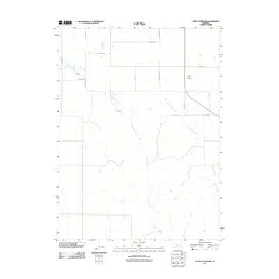
2011 Map of Hayes Center NW
USGS Topo · Published 2011About this map
Blackwood Creek meanders through the heart of this agricultural landscape in Lincoln County, Nebraska, defining the local drainage alongside Little Blackwood Creek. The rural topography is organized around a strictly surveyed grid of county roads, which reflect the family names and legacy of the local farming community. Notable landmarks like Pleasant View Cemetery sit along these routes, serving as historical anchor points for the surrounding township. This 2011 survey captures the area at a time when traditional gravel and dirt road networks, such as W Ingham Rd and W Gibson Rd, remained the primary infrastructure for navigating the high plains. The map's detail is useful for identifying specific homestead access points and property boundaries in this sparsely populated region north of Hayes Center.
Find a feature on this map
17 named features on this map. Tap any name to fly to it.
Don’t see what you’re looking for? This feature index may not catch every label — zoom into the map to look around manually.
Map Details
Editions of this 2011 Hayes Center NW Map
This is the sole edition of this map. No revisions or reprints were ever made.
Other maps of this area

1954 · McCook
USGS Topo · 1:250,000

1957 · McCook
USGS Topo · 1:250,000

1958 · McCook
USGS Topo · 1:250,000
1973 · Grainton
USGS Topo · 1:24,000

1973 · Dittons Creek NE
USGS Topo · 1:24,000

1973 · Suttlers Canyon West
USGS Topo · 1:24,000
1973 · Melton Ranch Airport
USGS Topo · 1:24,000
1973 · Wallace
USGS Topo · 1:24,000

1973 · Hayes Center NW
USGS Topo · 1:24,000

1974 · Dittons Creek SE
USGS Topo · 1:24,000