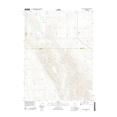
2014 Map of Hayes Center NW
USGS Topo · Published 2014About this map
Blackwood Cr and Little Blackwood Cr define the drainage of this rural expanse along the border of Lincoln and Hayes counties. The landscape is characterized by the transition from the relatively flat uplands in the north to the increasingly dissected breaks and drainage basins in the south. Pleasant View Cem stands as a focal point for genealogical research, situated near the intersection of Ingham Rd and Corner Rd. The section-line road network, including Parker Rd and S Blackwood Rd, reveals the methodical survey of the Nebraska prairie. This 2014 edition documents a region of cattle ranching and dryland farming, where individual tracks like Cecava Rd and W Gibson Rd connect isolated homesteads across the varied terrain of the High Plains.
Find a feature on this map
29 named features on this map. Tap any name to fly to it.
Don’t see what you’re looking for? This feature index may not catch every label — zoom into the map to look around manually.
Map Details
Editions of this 2014 Hayes Center NW Map
This is the sole edition of this map. No revisions or reprints were ever made.
Other maps of this area

1954 · McCook
USGS Topo · 1:250,000

1957 · McCook
USGS Topo · 1:250,000

1958 · McCook
USGS Topo · 1:250,000
1973 · Grainton
USGS Topo · 1:24,000

1973 · Dittons Creek NE
USGS Topo · 1:24,000

1973 · Suttlers Canyon West
USGS Topo · 1:24,000
1973 · Melton Ranch Airport
USGS Topo · 1:24,000
1973 · Wallace
USGS Topo · 1:24,000

1973 · Hayes Center NW
USGS Topo · 1:24,000

1974 · Dittons Creek SE
USGS Topo · 1:24,000