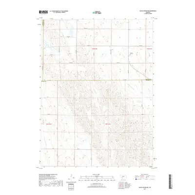
2017 Map of Hayes Center NW
USGS Topo · Published 2017About this map
The rolling tablelands of the High Plains intersect where Lincoln and Hayes counties meet in southwest Nebraska. This landscape is defined by the headwaters of Blackwood Creek and its tributary, Little Blackwood Creek, which carve dendritic drainage patterns through the agricultural terrain. The map serves as a vital record for family researchers, anchoring the rural community at the Pleasant View Cemetery near Corner Road. A network of section-line roads, including Brushy Road, Roland Road, and West Ingham Road, provides a geometric structure to the sparsely populated rangeland, tracing the legacy of the Public Land Survey System through Township 9 North and Township 8 North.
Find a feature on this map
28 named features on this map. Tap any name to fly to it.
Don’t see what you’re looking for? This feature index may not catch every label — zoom into the map to look around manually.
Map Details
Editions of this 2017 Hayes Center NW Map
This is the sole edition of this map. No revisions or reprints were ever made.
Other maps of this area

1954 · McCook
USGS Topo · 1:250,000

1957 · McCook
USGS Topo · 1:250,000

1958 · McCook
USGS Topo · 1:250,000
1973 · Grainton
USGS Topo · 1:24,000

1973 · Dittons Creek NE
USGS Topo · 1:24,000

1973 · Suttlers Canyon West
USGS Topo · 1:24,000
1973 · Melton Ranch Airport
USGS Topo · 1:24,000
1973 · Wallace
USGS Topo · 1:24,000

1973 · Hayes Center NW
USGS Topo · 1:24,000

1974 · Dittons Creek SE
USGS Topo · 1:24,000