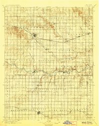
1896 Map of Hays
USGS Topo · Published 1906About this map
Big Creek and the Smoky Hill River carve the landscape of the western Kansas plains on this late nineteenth-century survey. The arrival of the Union Pacific railroad is the primary driver of development, connecting a string of Volga German settlements including Catharine, Victoria, and Munjor. These immigrant communities established their townships in the 1870s, and their footprints are clearly visible alongside the rail line and riverbanks. Further south, the Missouri Pacific railroad anchors the growing town of Lacrosse. The map reveals a highly structured grid of administrative boundaries such as Wheatland, Fairview, and Pleasant Dale, contrasting with the winding natural drainage of Big Timber Creek and Sand Creek. The terrain is punctuated by landmarks like the Hogback and Blue Hill, while the Lookout Hollow and Hungry Hollow suggest the difficulties faced by early settlers in this high-plains environment.
Find a feature on this map
59 named features on this map. Tap any name to fly to it.
Don’t see what you’re looking for? This feature index may not catch every label — zoom into the map to look around manually.
Map Details
Editions of this 1896 Hays Map
5 editions found

Other maps of this area

1889 · Larned
USGS Topo · 1:125,000

1891 · Great Bend
USGS Topo · 1:125,000

1891 · Larned
USGS Topo · 1:125,000

1892 · Ness
USGS Topo · 1:125,000

1893 · Ellis
USGS Topo · 1:125,000

1893 · Great Bend
USGS Topo · 1:125,000

1893 · Hill
USGS Topo · 1:125,000

1894 · Ness
USGS Topo · 1:125,000

1896 · Osborne
USGS Topo · 1:125,000

1896 · Russell
USGS Topo · 1:125,000