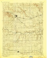
1896 Map of Hays
USGS Topo · Published 1924About this map
Hays serves as the primary hub of this late 19th-century landscape, situated where the Union Pacific R. R. follows the winding path of Big Creek. The settlement pattern reflects the arrival of German-Russian immigrants to the Kansas plains, with colonies like Catharine, Victoria, Pfeifer, Schoengen, and Liebenthal established along the riparian corridors. These agrarian communities are organized within named townships such as Freedom, Wheatland, and Pleasant Dale, illustrating the early township and range organization of Ellis and Rush counties. To the south, the Missouri Pacific R. R. anchors a second corridor of activity near Lacrosse and Bison. The terrain is defined by the broad valleys of the Smoky Hill River and Walnut Creek, interspersed with local landmarks like the Blue Hill and Hogback, which provided orientation for early travelers across the shortgrass prairie.
Find a feature on this map
55 named features on this map. Tap any name to fly to it.
Don’t see what you’re looking for? This feature index may not catch every label — zoom into the map to look around manually.
Map Details
Editions of this 1896 Hays Map
5 editions found

Other maps of this area

1889 · Larned
USGS Topo · 1:125,000

1891 · Great Bend
USGS Topo · 1:125,000

1891 · Larned
USGS Topo · 1:125,000

1892 · Ness
USGS Topo · 1:125,000

1893 · Ellis
USGS Topo · 1:125,000

1893 · Great Bend
USGS Topo · 1:125,000

1893 · Hill
USGS Topo · 1:125,000

1894 · Ness
USGS Topo · 1:125,000

1896 · Osborne
USGS Topo · 1:125,000

1896 · Russell
USGS Topo · 1:125,000