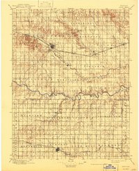
1896 Map of Hays
USGS Topo · Published 1943About this map
Hays and its surrounding prairie landscapes are documented in this late nineteenth-century reconnaissance survey, revealing a region defined by agricultural townships and strategic rail corridors. The Union Pacific R. R. serves as the primary artery for settlement, connecting the depots at Walker, Victoria, and Toulon. To the south, the meandering Smoky Hill River cuts through the terrain, flanked by numerous small communities including Schoengen and Pfeifer. Further south still, the Missouri Pacific R. R. establishes a second industrial corridor through Lacrosse and Bison. This map is particularly valuable for its depiction of distinct ethnic and religious enclaves, such as the German-Russian settlements of Catharine and Munjor, appearing as they did shortly after their founding. The landscape is a network of named hollows and creeks, like Hogback Hollow and Big Timber Creek, which provided essential water sources for the early homesteads and cattle operations across the Hampton and Pleasant Dale districts.
Find a feature on this map
54 named features on this map. Tap any name to fly to it.
Don’t see what you’re looking for? This feature index may not catch every label — zoom into the map to look around manually.
Map Details
Editions of this 1896 Hays Map
5 editions found

Other maps of this area

1889 · Larned
USGS Topo · 1:125,000

1891 · Great Bend
USGS Topo · 1:125,000

1891 · Larned
USGS Topo · 1:125,000

1892 · Ness
USGS Topo · 1:125,000

1893 · Ellis
USGS Topo · 1:125,000

1893 · Great Bend
USGS Topo · 1:125,000

1893 · Hill
USGS Topo · 1:125,000

1894 · Ness
USGS Topo · 1:125,000

1896 · Osborne
USGS Topo · 1:125,000

1896 · Russell
USGS Topo · 1:125,000