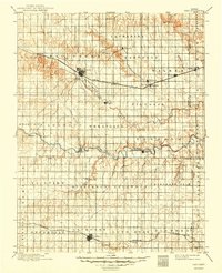
1896 Map of Hays
USGS Topo · Published 1949About this map
Hays and Lacrosse serve as the primary rail hubs in this late 19th-century landscape, connected by the Union Pacific R. R. and Missouri Pacific R. R. respectively. The settlement pattern reveals the cultural footprint of the Volga German pioneers who established colonies such as Catharine, Victoria, Pfeifer, and Liebenthal across the rolling plains. These communities are strategically positioned near water sources like Big Creek and the Smoky Hill River, which carve distinct drainage patterns through the terrain. The map meticulously documents the transition from open prairie to a grid of organized townships including Wheatland, Freedom, and Illinois. For researchers, the presence of smaller stops such as Toulon, Walker, and Bison along the rail lines provides a clear view of the late Victorian era transport network that sustained these agricultural outposts.
Find a feature on this map
52 named features on this map. Tap any name to fly to it.
Don’t see what you’re looking for? This feature index may not catch every label — zoom into the map to look around manually.
Map Details
Editions of this 1896 Hays Map
5 editions found

Other maps of this area

1889 · Larned
USGS Topo · 1:125,000

1891 · Great Bend
USGS Topo · 1:125,000

1891 · Larned
USGS Topo · 1:125,000

1892 · Ness
USGS Topo · 1:125,000

1893 · Ellis
USGS Topo · 1:125,000

1893 · Great Bend
USGS Topo · 1:125,000

1893 · Hill
USGS Topo · 1:125,000

1894 · Ness
USGS Topo · 1:125,000

1896 · Osborne
USGS Topo · 1:125,000

1896 · Russell
USGS Topo · 1:125,000