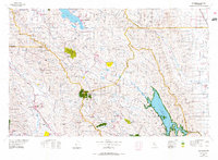
1972 Map of Healdsburg
USGS Topo · Published 1975About this map
Clear Lake and the volcanic peak of Mount Konocti anchor the northern landscape of this region, which includes the southern portion of Lake County and the wine-growing valleys of Sonoma and Napa. This 1972 survey shows a transition between the established vineyards of the Napa Valley and Alexander Valley and the developing recreation areas around Lake Berryessa State Recreation Area. The Northwestern Pacific railroad corridor traces the Russian River through Healdsburg and Geyserville, serving the timber and agricultural hubs of the era. Public lands are prominently established, including Boggs Mountain State Forest and the Robert Louis Stevenson Memorial State Park surrounding Mount St Helena, illustrating the balance of resource management and early 1970s land preservation in the North Bay counties.
Find a feature on this map
65 named features on this map. Tap any name to fly to it.
Don’t see what you’re looking for? This feature index may not catch every label — zoom into the map to look around manually.
Map Details
Editions of this 1972 Healdsburg Map
2 editions found
Other maps of this area

1888 · Marysville
USGS Topo · 1:125,000

1891 · Marysville
USGS Topo · 1:125,000

1894 · Marysville
USGS Topo · 1:125,000

1895 · Marysville
USGS Topo · 1:125,000

1902 · Napa
USGS Topo · 1:125,000

1905 · Harrington
USGS Topo · 1:24,000

1905 · Esparto
USGS Topo · 1:24,000

1907 · Dunnigan
USGS Topo · 1:62,500

1907 · Colusa
USGS Topo · 1:62,500

1907 · Woodland
USGS Topo · 1:62,500