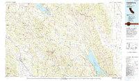
1972 Map of Healdsburg
USGS Topo · Published 1993About this map
The Northwestern Pacific railroad follows the winding path of the Russian River in this 1972 survey, passing through Healdsburg and Geyserville during a period of significant regional growth. The landscape is defined by the transition from the fertile valleys of Sonoma and Napa counties to the higher elevations of the Mayacmas Mountains. Large bodies of water including Clear Lake and Lake Berryessa dominate the northern and eastern portions of the map, illustrating the scale of California's water management and recreation infrastructure during the early 1970s.
Find a feature on this map
167 named features on this map. Tap any name to fly to it.
Don’t see what you’re looking for? This feature index may not catch every label — zoom into the map to look around manually.
Map Details
Editions of this 1972 Healdsburg Map
2 editions found
Other maps of this area

1888 · Marysville
USGS Topo · 1:125,000

1891 · Marysville
USGS Topo · 1:125,000

1894 · Marysville
USGS Topo · 1:125,000

1895 · Marysville
USGS Topo · 1:125,000

1902 · Napa
USGS Topo · 1:125,000

1905 · Harrington
USGS Topo · 1:24,000

1905 · Esparto
USGS Topo · 1:24,000

1907 · Dunnigan
USGS Topo · 1:62,500

1907 · Colusa
USGS Topo · 1:62,500

1907 · Woodland
USGS Topo · 1:62,500