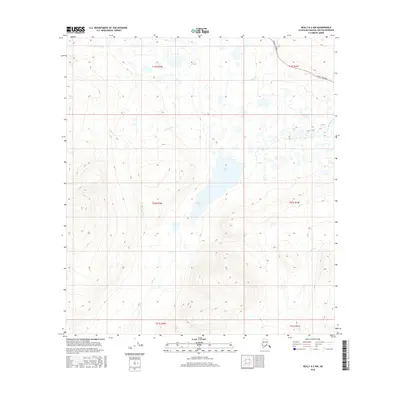
2016 Map of Healy A-2 NW
USGS Topo · Published 2016About this map
Butte Lake sits at the heart of this high-altitude landscape in the Matanuska-Susitna region, surrounded by a complex network of glacial drainage. The northern reaches of the quadrangle are crossed by the Denali Highway, which provides the primary access to this remote interior corridor. Several major watercourses define the local topography, including Canyon Cr and Butte Cr, which carve through the high terrain. The map also captures the eastern flow of Monahan Cr and the southern drainage of Gold Cr. This 2016 survey emphasizes the wilderness character of the area, where public land survey system boundaries like t20s r2w and t21s r1w provide a structural grid over a largely untouched landscape of lakes and seasonal stream systems.
Find a feature on this map
12 named features on this map. Tap any name to fly to it.
Don’t see what you’re looking for? This feature index may not catch every label — zoom into the map to look around manually.
Map Details
Editions of this 2016 Healy A-2 NW Map
This is the sole edition of this map. No revisions or reprints were ever made.
Other maps of this area

1949 · Healy B-2
USGS Topo · 1:63,360

1950 · Healy A-3
USGS Topo · 1:63,360

1950 · Healy B-3
USGS Topo · 1:63,360

1951 · Healy
USGS Topo · 1:250,000

1951 · Healy A-2
USGS Topo · 1:63,360
1952 · Healy A-3
USGS Topo · 1:63,360
1952 · Healy B-3
USGS Topo · 1:63,360

1952 · Healy A-2
USGS Topo · 1:63,360

1952 · Healy B-2
USGS Topo · 1:63,360

1956 · Healy
USGS Topo · 1:250,000