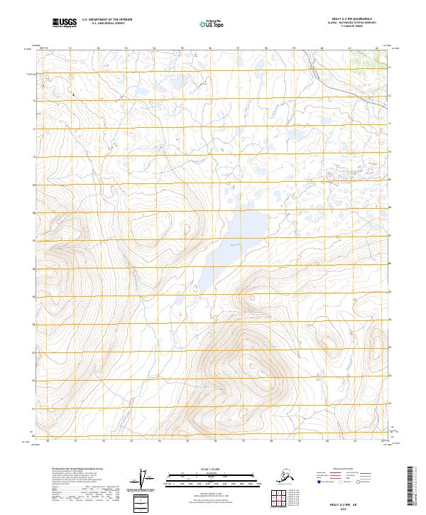
2024 Map of Healy A-2 NW
USGS Topo · Published 2024About this map
Butte Lake sits at the center of this Matanuska-Susitna region, surrounded by a complex network of waterways and high-elevation terrain. This survey illustrates the northern passage of the Denali Highway as it cuts through the northeastern corner of the map, providing the primary access point to this subarctic landscape. The drainage patterns are clearly defined by Canyon Creek in the north and the winding course of Butte Creek which feeds into the lake from the south. To the southeast, Gold Creek flows through deep contour lines, suggesting the steep elevation changes characteristic of the Clearwater Mountains vicinity. The map provides a precise look at the township and range boundaries, including t20s r2w and t20s r1w, which are essential for land navigation and modern property research in this part of the Alaska interior.
Find a feature on this map
11 named features on this map. Tap any name to fly to it.
Don’t see what you’re looking for? This feature index may not catch every label — zoom into the map to look around manually.
Map Details
Editions of this 2024 Healy A-2 NW Map
This is the sole edition of this map. No revisions or reprints were ever made.
Other maps of this area

1949 · Healy B-2
USGS Topo · 1:63,360

1950 · Healy A-3
USGS Topo · 1:63,360

1950 · Healy B-3
USGS Topo · 1:63,360

1951 · Healy
USGS Topo · 1:250,000

1951 · Healy A-2
USGS Topo · 1:63,360
1952 · Healy A-3
USGS Topo · 1:63,360
1952 · Healy B-3
USGS Topo · 1:63,360

1952 · Healy A-2
USGS Topo · 1:63,360

1952 · Healy B-2
USGS Topo · 1:63,360

1956 · Healy
USGS Topo · 1:250,000