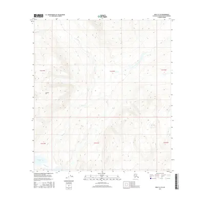
2016 Map of Healy A-3 SE
USGS Topo · Published 2016About this map
Deadman Mtn dominates this interior Alaskan landscape, serving as a primary high point within the Talkeetna Mountains region. The Deadman Cr drainage system carves a winding path across the terrain, flowing through several sections of the Public Land Survey System including t21s r4w and t21s r3w. In the southwest corner, Deadman Lake provides a distinct landmark amidst the high-elevation contours. This 2016 survey, produced by the U.S. Geological Survey, illustrates a wilderness area defined by its significant relief and hydraulic network, largely devoid of modern road infrastructure or permanent settlements. The map provides precise topographic data for the Matanuska-Susitna Borough, reflecting the untouched character of the subarctic tundra and mountain environment.
Find a feature on this map
9 named features on this map. Tap any name to fly to it.
Don’t see what you’re looking for? This feature index may not catch every label — zoom into the map to look around manually.
Map Details
Editions of this 2016 Healy A-3 SE Map
This is the sole edition of this map. No revisions or reprints were ever made.
Other maps of this area

1950 · Talkeetna Mountains
USGS Topo · 1:250,000

1950 · Healy A-3
USGS Topo · 1:63,360

1951 · Healy
USGS Topo · 1:250,000

1951 · Talkeetna Mountains D-2
USGS Topo · 1:63,360

1951 · Talkeetna Mountains D-3
USGS Topo · 1:63,360

1951 · Healy A-2
USGS Topo · 1:63,360
1952 · Healy A-3
USGS Topo · 1:63,360

1952 · Healy A-2
USGS Topo · 1:63,360
1952 · Talkeetna Mountains D-2
USGS Topo · 1:63,360
1953 · Talkeetna Mountains D-3
USGS Topo · 1:63,360