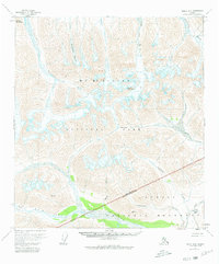
1954 Map of Healy B-6
USGS Topo · Published 1995About this map
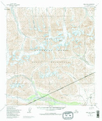
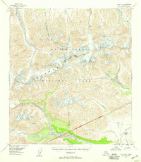
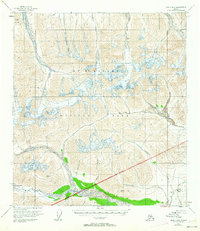
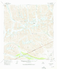
Denali National Park and the surrounding wilderness of the Matanuska-Susitna Borough are defined by an expansive glacial and riverine landscape in this mid-century survey. The high elevations of Mount Pendleton and Divide Mountain overlook massive ice fields like Polychrome Glacier and West Fork Glacier. The terrain transitions from these frozen heights into a network of braided watercourses, including the north-flowing Toklat River and the southward drainage of the Chulitna River. Evidence of early industrial and transit activity appears in the southeastern corner near the Wilderness Boundary, where the Dunkle Mine and a remote Landing Strip sit along Camp Creek. This area provides a look at the intersection of protected federal land and resource extraction, connected only by an Unimproved dirt track that snakes through the mountain passes near Easy Pass.
Find a feature on this map
25 named features on this map. Tap any name to fly to it.
Don’t see what you’re looking for? This feature index may not catch every label — zoom into the map to look around manually.
Map Details
Editions of this 1954 Healy B-6 Map
7 editions found
Historical Maps of Matanuska-Susitna Through Time
1048 maps found

1948 Anchorage D-1
Matanuska-Susitna Borough, AK

1948 Anchorage D-2
Matanuska-Susitna Borough, AK

1948 Anchorage D-3
Matanuska-Susitna Borough, AK

1948 Anchorage D-4
Matanuska-Susitna Borough, AK

1949 Anchorage D-5
Matanuska-Susitna Borough, AK

1949 Anchorage D-7
Matanuska-Susitna Borough, AK

1949 Anchorage D-8
Matanuska-Susitna Borough, AK

1949 Gulkana A-5
Matanuska-Susitna Borough, AK

1949 Gulkana A-6
Matanuska-Susitna Borough, AK

1949 Healy A-1
Matanuska-Susitna Borough, AK

1949 Healy A-6
Matanuska-Susitna Borough, AK

1949 Mount Hayes A-5
Matanuska-Susitna Borough, AK

1949 Talkeetna Mountains A-1
Matanuska-Susitna Borough, AK

1949 Talkeetna Mountains A-4
Matanuska-Susitna Borough, AK

1949 Talkeetna Mountains B-6
Matanuska-Susitna Borough, AK

1949 Talkeetna Mountains C-6
Matanuska-Susitna Borough, AK

1949 Talkeetna Mountains D-6
Matanuska-Susitna Borough, AK

1949 Valdez D-8
Matanuska-Susitna Borough, AK

1950 Anchorage C-7
Matanuska-Susitna Borough, AK

1950 Anchorage C-8
Matanuska-Susitna Borough, AK

1950 Anchorage D-6
Matanuska-Susitna Borough, AK

1950 Gulkana B-6
Matanuska-Susitna Borough, AK

1950 Healy A-3
Matanuska-Susitna Borough, AK

1950 Healy A-4
Matanuska-Susitna Borough, AK

1950 Healy A-5
Matanuska-Susitna Borough, AK

1950 Healy B-1
Matanuska-Susitna Borough, AK

1950 Mt. Hayes A-6
Matanuska-Susitna Borough, AK

1950 Talkeetna Mountains A-5
Matanuska-Susitna Borough, AK

1950 Talkeetna Mountains A-6
Matanuska-Susitna Borough, AK

1950 Talkeetna Mountains B-4
Matanuska-Susitna Borough, AK

1950 Talkeetna Mountains B-5
Matanuska-Susitna Borough, AK

1950 Talkeetna Mountains C-5
Matanuska-Susitna Borough, AK

1950 Talkeetna Mountains D-5
Matanuska-Susitna Borough, AK

1950 Talkeetna Mountains
Matanuska-Susitna Borough, AK

1951 Anchorage C-5
Matanuska-Susitna Borough, AK

1951 Anchorage C-6
Matanuska-Susitna Borough, AK

1951 Anchorage C-7
Matanuska-Susitna Borough, AK

1951 Anchorage D-1
Matanuska-Susitna Borough, AK

1951 Anchorage D-7
Matanuska-Susitna Borough, AK

1951 Anchorage D-8
Matanuska-Susitna Borough, AK

1951 Gulkana B-5
Matanuska-Susitna Borough, AK

1951 Gulkana C-5
Matanuska-Susitna Borough, AK

1951 Gulkana C-6
Matanuska-Susitna Borough, AK

1951 Gulkana D-5
Matanuska-Susitna Borough, AK

1951 Gulkana D-6
Matanuska-Susitna Borough, AK

1951 Gulkana
Matanuska-Susitna Borough, AK

1951 Healy A-2
Matanuska-Susitna Borough, AK

1951 Mount Hayes B-5
Matanuska-Susitna Borough, AK

1951 Mount Hayes B-6
Matanuska-Susitna Borough, AK

1951 Talkeetna B-1
Matanuska-Susitna Borough, AK

1951 Talkeetna C-1
Matanuska-Susitna Borough, AK

1951 Talkeetna Mountains A-2
Matanuska-Susitna Borough, AK

1951 Talkeetna Mountains A-3
Matanuska-Susitna Borough, AK

1951 Talkeetna Mountains B-1
Matanuska-Susitna Borough, AK

1951 Talkeetna Mountains B-2
Matanuska-Susitna Borough, AK

1951 Talkeetna Mountains B-3
Matanuska-Susitna Borough, AK

1951 Talkeetna Mountains C-1
Matanuska-Susitna Borough, AK

1951 Talkeetna Mountains C-2
Matanuska-Susitna Borough, AK

1951 Talkeetna Mountains C-3
Matanuska-Susitna Borough, AK

1951 Talkeetna Mountains C-4
Matanuska-Susitna Borough, AK

1951 Talkeetna Mountains D-1
Matanuska-Susitna Borough, AK

1951 Talkeetna Mountains D-2
Matanuska-Susitna Borough, AK

1951 Talkeetna Mountains D-3
Matanuska-Susitna Borough, AK

1951 Talkeetna Mountains D-4
Matanuska-Susitna Borough, AK

1951 Talkeetna Mountains D-5
Matanuska-Susitna Borough, AK

1951 Talkeetna Mountains D-6
Matanuska-Susitna Borough, AK

1952 Anchorage B-8
Matanuska-Susitna Borough, AK

1952 Anchorage C-5
Matanuska-Susitna Borough, AK

1952 Anchorage C-7
Matanuska-Susitna Borough, AK

1952 Anchorage C-8
Matanuska-Susitna Borough, AK

1952 Anchorage D-2
Matanuska-Susitna Borough, AK

1952 Anchorage D-3
Matanuska-Susitna Borough, AK

1952 Anchorage D-4
Matanuska-Susitna Borough, AK

1952 Anchorage D-5
Matanuska-Susitna Borough, AK

1952 Anchorage D-6
Matanuska-Susitna Borough, AK

1952 Anchorage D-7
Matanuska-Susitna Borough, AK

1952 Anchorage D-8
Matanuska-Susitna Borough, AK

1952 Gulkana A-5
Matanuska-Susitna Borough, AK

1952 Gulkana A-6
Matanuska-Susitna Borough, AK

1952 Gulkana B-5
Matanuska-Susitna Borough, AK

1952 Gulkana B-6
Matanuska-Susitna Borough, AK

1952 Gulkana C-5
Matanuska-Susitna Borough, AK

1952 Gulkana C-6
Matanuska-Susitna Borough, AK

1952 Gulkana D-5
Matanuska-Susitna Borough, AK

1952 Gulkana D-6
Matanuska-Susitna Borough, AK

1952 Healy A-1
Matanuska-Susitna Borough, AK

1952 Healy A-2
Matanuska-Susitna Borough, AK

1952 Healy A-3
Matanuska-Susitna Borough, AK

1952 Healy A-4
Matanuska-Susitna Borough, AK

1952 Healy A-5
Matanuska-Susitna Borough, AK

1952 Healy B-1
Matanuska-Susitna Borough, AK

1952 Mount Hayes A-5
Matanuska-Susitna Borough, AK

1952 Mount Hayes A-6
Matanuska-Susitna Borough, AK

1952 Talkeetna A-1
Matanuska-Susitna Borough, AK

1952 Talkeetna Mountains A-1
Matanuska-Susitna Borough, AK

1952 Talkeetna Mountains A-2
Matanuska-Susitna Borough, AK

1952 Talkeetna Mountains A-3
Matanuska-Susitna Borough, AK

1952 Talkeetna Mountains A-5
Matanuska-Susitna Borough, AK

1952 Talkeetna Mountains A-6
Matanuska-Susitna Borough, AK

1952 Talkeetna Mountains B-1
Matanuska-Susitna Borough, AK

1952 Talkeetna Mountains B-2
Matanuska-Susitna Borough, AK

1952 Talkeetna Mountains B-3
Matanuska-Susitna Borough, AK

1952 Talkeetna Mountains B-4
Matanuska-Susitna Borough, AK

1952 Talkeetna Mountains B-5
Matanuska-Susitna Borough, AK

1952 Talkeetna Mountains B-6
Matanuska-Susitna Borough, AK

1952 Talkeetna Mountains C-1
Matanuska-Susitna Borough, AK

1952 Talkeetna Mountains C-2
Matanuska-Susitna Borough, AK

1952 Talkeetna Mountains C-3
Matanuska-Susitna Borough, AK

1952 Talkeetna Mountains C-4
Matanuska-Susitna Borough, AK

1952 Talkeetna Mountains C-5
Matanuska-Susitna Borough, AK

1952 Talkeetna Mountains C-6
Matanuska-Susitna Borough, AK

1952 Talkeetna Mountains D-1
Matanuska-Susitna Borough, AK

1952 Talkeetna Mountains D-2
Matanuska-Susitna Borough, AK

1952 Talkeetna Mountains D-4
Matanuska-Susitna Borough, AK

1952 Talkeetna Mountains D-6
Matanuska-Susitna Borough, AK

1952 Tyonek C-1
Matanuska-Susitna Borough, AK

1952 Tyonek D-1
Matanuska-Susitna Borough, AK

1952 Valdez D-8
Matanuska-Susitna Borough, AK

1952 Valdez
Matanuska-Susitna Borough, AK

1953 Anchorage B-8
Matanuska-Susitna Borough, AK

1953 Healy A-6
Matanuska-Susitna Borough, AK

1953 Talkeetna Mountains D-3
Matanuska-Susitna Borough, AK

1954 Healy B-6
Matanuska-Susitna Borough, AK

1954 Mount McKinley A-1
Matanuska-Susitna Borough, AK

1954 Talkeetna A-2
Matanuska-Susitna Borough, AK

1954 Talkeetna A-3
Matanuska-Susitna Borough, AK

1954 Talkeetna A-4
Matanuska-Susitna Borough, AK

1954 Talkeetna B-2
Matanuska-Susitna Borough, AK

1954 Talkeetna B-3
Matanuska-Susitna Borough, AK

1954 Talkeetna B-4
Matanuska-Susitna Borough, AK

1954 Talkeetna Mountains A-4
Matanuska-Susitna Borough, AK

1954 Talkeetna Mountains
Matanuska-Susitna Borough, AK

1954 Tyonek B-4
Matanuska-Susitna Borough, AK

1954 Tyonek C-3
Matanuska-Susitna Borough, AK

1954 Tyonek C-4
Matanuska-Susitna Borough, AK

1954 Tyonek C-5
Matanuska-Susitna Borough, AK

1954 Tyonek D-1
Matanuska-Susitna Borough, AK

1954 Tyonek D-2
Matanuska-Susitna Borough, AK

1954 Tyonek D-3
Matanuska-Susitna Borough, AK

1954 Tyonek D-4
Matanuska-Susitna Borough, AK

1954 Tyonek D-5
Matanuska-Susitna Borough, AK

1957 Talkeetna Mountains
Matanuska-Susitna Borough, AK

1958 Talkeetna A-1
Matanuska-Susitna Borough, AK

1958 Talkeetna A-5
Matanuska-Susitna Borough, AK

1958 Talkeetna A-6
Matanuska-Susitna Borough, AK

1958 Talkeetna B-1
Matanuska-Susitna Borough, AK

1958 Talkeetna B-5
Matanuska-Susitna Borough, AK

1958 Talkeetna B-6
Matanuska-Susitna Borough, AK

1958 Talkeetna C-1
Matanuska-Susitna Borough, AK

1958 Talkeetna C-2
Matanuska-Susitna Borough, AK

1958 Talkeetna C-3
Matanuska-Susitna Borough, AK

1958 Talkeetna C-4
Matanuska-Susitna Borough, AK

1958 Talkeetna C-5
Matanuska-Susitna Borough, AK

1958 Talkeetna C-6
Matanuska-Susitna Borough, AK

1958 Talkeetna D-1
Matanuska-Susitna Borough, AK

1958 Talkeetna D-2
Matanuska-Susitna Borough, AK

1958 Talkeetna D-3
Matanuska-Susitna Borough, AK

1958 Tyonek B-1
Matanuska-Susitna Borough, AK

1958 Tyonek B-2
Matanuska-Susitna Borough, AK

1958 Tyonek B-3
Matanuska-Susitna Borough, AK

1958 Tyonek C-1
Matanuska-Susitna Borough, AK

1958 Tyonek C-2
Matanuska-Susitna Borough, AK

1958 Tyonek C-6
Matanuska-Susitna Borough, AK

1958 Tyonek C-7
Matanuska-Susitna Borough, AK

1958 Tyonek C-8
Matanuska-Susitna Borough, AK

1958 Tyonek D-6
Matanuska-Susitna Borough, AK

1958 Tyonek D-7
Matanuska-Susitna Borough, AK

1958 Tyonek D-8
Matanuska-Susitna Borough, AK

1959 Gulkana
Matanuska-Susitna Borough, AK

1960 Anchorage B-1
Matanuska-Susitna Borough, AK

1960 Anchorage B-2
Matanuska-Susitna Borough, AK

1960 Anchorage B-3
Matanuska-Susitna Borough, AK

1960 Anchorage C-1
Matanuska-Susitna Borough, AK

1960 Anchorage C-2
Matanuska-Susitna Borough, AK

1960 Anchorage C-3
Matanuska-Susitna Borough, AK

1960 Anchorage C-4
Matanuska-Susitna Borough, AK

1960 Anchorage C-5
Matanuska-Susitna Borough, AK

1960 Valdez B-8
Matanuska-Susitna Borough, AK

1960 Valdez C-8
Matanuska-Susitna Borough, AK

1960 Valdez
Matanuska-Susitna Borough, AK

1962 Healy A-2
Matanuska-Susitna Borough, AK

1965 Anchorage B-8
Matanuska-Susitna Borough, AK

1965 Gulkana
Matanuska-Susitna Borough, AK

1966 Talkeetna Mountains
Matanuska-Susitna Borough, AK

1976 Anchorage D-2
Matanuska-Susitna Borough, AK

1979 Anchorage B-6 NW
Matanuska-Susitna Borough, AK

1979 Anchorage B-8 NE
Matanuska-Susitna Borough, AK

1979 Anchorage B-8 SW
Matanuska-Susitna Borough, AK

1979 Anchorage C-6 NE
Matanuska-Susitna Borough, AK

1979 Anchorage C-6 NW
Matanuska-Susitna Borough, AK

1979 Anchorage C-6 SE
Matanuska-Susitna Borough, AK

1979 Anchorage C-6 SW
Matanuska-Susitna Borough, AK

1979 Anchorage C-7 NE
Matanuska-Susitna Borough, AK

1979 Anchorage C-7 NW
Matanuska-Susitna Borough, AK

1979 Anchorage C-7 SE
Matanuska-Susitna Borough, AK

1979 Anchorage C-7 SW
Matanuska-Susitna Borough, AK

1979 Anchorage C-8 NE
Matanuska-Susitna Borough, AK

1979 Anchorage C-8 NW
Matanuska-Susitna Borough, AK

1979 Anchorage C-8 SE
Matanuska-Susitna Borough, AK

1979 Anchorage C-8 SW
Matanuska-Susitna Borough, AK

1979 Tyonek A-1 NW
Matanuska-Susitna Borough, AK

1979 Tyonek B-1 NE
Matanuska-Susitna Borough, AK

1979 Tyonek B-1 SE
Matanuska-Susitna Borough, AK

1979 Tyonek C-1 NE
Matanuska-Susitna Borough, AK

1979 Tyonek C-1 SE
Matanuska-Susitna Borough, AK

1983 Anchorage D-7 SW
Matanuska-Susitna Borough, AK

1983 Anchorage D-8 SE
Matanuska-Susitna Borough, AK

1983 Anchorage D-8 SW
Matanuska-Susitna Borough, AK

1983 Tyonek D-1 SE
Matanuska-Susitna Borough, AK

1987 Talkeetna A-1 NE
Matanuska-Susitna Borough, AK

1987 Talkeetna A-1 SE
Matanuska-Susitna Borough, AK

1987 Talkeetna B-1 NE
Matanuska-Susitna Borough, AK

1987 Talkeetna B-1 NW
Matanuska-Susitna Borough, AK

1987 Talkeetna B-1 SE
Matanuska-Susitna Borough, AK

1987 Talkeetna B-1 SW
Matanuska-Susitna Borough, AK

1987 Talkeetna C-1 SE
Matanuska-Susitna Borough, AK

1987 Tyonek D-1 NE
Matanuska-Susitna Borough, AK

1992 Anchorage C-6 SW
Matanuska-Susitna Borough, AK

1992 Anchorage C-7 SE
Matanuska-Susitna Borough, AK

1992 Anchorage C-7 SW
Matanuska-Susitna Borough, AK

1992 Anchorage C-8 SE
Matanuska-Susitna Borough, AK

1993 Anchorage C-2
Matanuska-Susitna Borough, AK

1993 Anchorage C-3
Matanuska-Susitna Borough, AK

1993 Anchorage D-1
Matanuska-Susitna Borough, AK

1993 Anchorage D-2
Matanuska-Susitna Borough, AK

1993 Anchorage D-3
Matanuska-Susitna Borough, AK

1993 Tyonek C-1
Matanuska-Susitna Borough, AK

1993 Tyonek C-2
Matanuska-Susitna Borough, AK

1993 Tyonek C-3
Matanuska-Susitna Borough, AK

1993 Tyonek D-1
Matanuska-Susitna Borough, AK

1993 Tyonek D-2
Matanuska-Susitna Borough, AK

1993 Tyonek D-3
Matanuska-Susitna Borough, AK

1993 Tyonek D-4
Matanuska-Susitna Borough, AK

1993 Valdez C-8
Matanuska-Susitna Borough, AK

1993 Valdez D-8
Matanuska-Susitna Borough, AK

1994 Anchorage B-8
Matanuska-Susitna Borough, AK

1994 Anchorage C-4
Matanuska-Susitna Borough, AK

1994 Anchorage C-5
Matanuska-Susitna Borough, AK

1994 Anchorage C-6
Matanuska-Susitna Borough, AK

1994 Anchorage C-7
Matanuska-Susitna Borough, AK

1994 Anchorage C-8
Matanuska-Susitna Borough, AK

1994 Anchorage D-4
Matanuska-Susitna Borough, AK

1994 Anchorage D-5
Matanuska-Susitna Borough, AK

1994 Anchorage D-6
Matanuska-Susitna Borough, AK

1994 Anchorage D-7
Matanuska-Susitna Borough, AK

1994 Anchorage D-8
Matanuska-Susitna Borough, AK

1994 Talkeetna A-1
Matanuska-Susitna Borough, AK

1994 Talkeetna A-2
Matanuska-Susitna Borough, AK

1994 Talkeetna B-1
Matanuska-Susitna Borough, AK

1994 Talkeetna B-2
Matanuska-Susitna Borough, AK

2013 Anchorage B-1 NW
Matanuska-Susitna Borough, AK

2013 Anchorage B-2 NE
Matanuska-Susitna Borough, AK

2013 Anchorage B-2 NW
Matanuska-Susitna Borough, AK

2013 Anchorage B-3 NE
Matanuska-Susitna Borough, AK

2013 Anchorage B-3 NW
Matanuska-Susitna Borough, AK

2013 Anchorage B-4 NE
Matanuska-Susitna Borough, AK

2013 Anchorage B-4 NW
Matanuska-Susitna Borough, AK

2013 Anchorage B-5 NE
Matanuska-Susitna Borough, AK

2013 Anchorage B-5 NW
Matanuska-Susitna Borough, AK

2013 Anchorage B-6 NE
Matanuska-Susitna Borough, AK

2013 Anchorage C-1 NW
Matanuska-Susitna Borough, AK

2013 Anchorage C-1 SW
Matanuska-Susitna Borough, AK

2013 Anchorage C-2 NE
Matanuska-Susitna Borough, AK

2013 Anchorage C-2 NW
Matanuska-Susitna Borough, AK

2013 Anchorage C-2 SE
Matanuska-Susitna Borough, AK

2013 Anchorage C-2 SW
Matanuska-Susitna Borough, AK

2013 Anchorage C-3 SE
Matanuska-Susitna Borough, AK

2013 Anchorage C-3 SW
Matanuska-Susitna Borough, AK

2013 Anchorage C-4 SE
Matanuska-Susitna Borough, AK

2013 Anchorage D-1 NW
Matanuska-Susitna Borough, AK

2013 Anchorage D-1 SW
Matanuska-Susitna Borough, AK

2013 Anchorage D-2 NE
Matanuska-Susitna Borough, AK

2013 Anchorage D-2 NW
Matanuska-Susitna Borough, AK

2013 Anchorage D-2 SE
Matanuska-Susitna Borough, AK

2013 Anchorage D-2 SW
Matanuska-Susitna Borough, AK

2013 Gulkana A-6 NE
Matanuska-Susitna Borough, AK

2013 Gulkana A-6 NW
Matanuska-Susitna Borough, AK

2013 Gulkana A-6 SW
Matanuska-Susitna Borough, AK

2013 Gulkana B-5 NW
Matanuska-Susitna Borough, AK

2013 Gulkana B-5 SW
Matanuska-Susitna Borough, AK

2013 Gulkana B-6 SE
Matanuska-Susitna Borough, AK

2013 Gulkana B-6 SW
Matanuska-Susitna Borough, AK

2013 Talkeetna A-3 NE
Matanuska-Susitna Borough, AK

2013 Talkeetna B-1 NW
Matanuska-Susitna Borough, AK

2013 Talkeetna B-1 SW
Matanuska-Susitna Borough, AK

2013 Talkeetna B-2 NE
Matanuska-Susitna Borough, AK

2013 Talkeetna B-2 NW
Matanuska-Susitna Borough, AK

2013 Talkeetna B-2 SE
Matanuska-Susitna Borough, AK

2013 Talkeetna B-2 SW
Matanuska-Susitna Borough, AK

2013 Talkeetna B-3 SE
Matanuska-Susitna Borough, AK

2013 Talkeetna B-3 SW
Matanuska-Susitna Borough, AK

2013 Talkeetna C-2 SE
Matanuska-Susitna Borough, AK

2013 Talkeetna Mountains A-1 NE
Matanuska-Susitna Borough, AK

2013 Talkeetna Mountains A-1 NW
Matanuska-Susitna Borough, AK

2013 Talkeetna Mountains A-1 SE
Matanuska-Susitna Borough, AK

2013 Talkeetna Mountains A-1 SW
Matanuska-Susitna Borough, AK

2013 Talkeetna Mountains A-2 NE
Matanuska-Susitna Borough, AK

2013 Talkeetna Mountains A-2 SE
Matanuska-Susitna Borough, AK

2013 Talkeetna Mountains B-1 SE
Matanuska-Susitna Borough, AK

2013 Talkeetna Mountains B-1 SW
Matanuska-Susitna Borough, AK

2013 Talkeetna Mountains B-2 SE
Matanuska-Susitna Borough, AK

2013 Tyonek A-1 NW
Matanuska-Susitna Borough, AK

2013 Tyonek A-2 NE
Matanuska-Susitna Borough, AK

2013 Tyonek A-2 NW
Matanuska-Susitna Borough, AK

2013 Tyonek A-3 NE
Matanuska-Susitna Borough, AK

2013 Tyonek B-1 NE
Matanuska-Susitna Borough, AK

2013 Tyonek B-1 SE
Matanuska-Susitna Borough, AK

2013 Tyonek B-1 SW
Matanuska-Susitna Borough, AK

2013 Tyonek B-2 SE
Matanuska-Susitna Borough, AK

2013 Tyonek B-2 SW
Matanuska-Susitna Borough, AK

2013 Tyonek B-3 SE
Matanuska-Susitna Borough, AK

2013 Tyonek B-3 SW
Matanuska-Susitna Borough, AK

2013 Tyonek B-4 SE
Matanuska-Susitna Borough, AK

2014 Talkeetna B-3 NE
Matanuska-Susitna Borough, AK

2014 Talkeetna B-3 NW
Matanuska-Susitna Borough, AK

2014 Talkeetna C-2 NE
Matanuska-Susitna Borough, AK

2014 Talkeetna C-2 NW
Matanuska-Susitna Borough, AK

2014 Talkeetna C-2 SW
Matanuska-Susitna Borough, AK

2014 Talkeetna C-3 NE
Matanuska-Susitna Borough, AK

2014 Talkeetna C-3 NW
Matanuska-Susitna Borough, AK

2014 Talkeetna C-3 SE
Matanuska-Susitna Borough, AK

2014 Talkeetna C-3 SW
Matanuska-Susitna Borough, AK

2014 Talkeetna C-4 NE
Matanuska-Susitna Borough, AK

2014 Talkeetna C-4 NW
Matanuska-Susitna Borough, AK

2014 Talkeetna D-2 NE
Matanuska-Susitna Borough, AK

2014 Talkeetna D-2 NW
Matanuska-Susitna Borough, AK

2014 Talkeetna D-2 SE
Matanuska-Susitna Borough, AK

2014 Talkeetna D-2 SW
Matanuska-Susitna Borough, AK

2014 Talkeetna D-3 SE
Matanuska-Susitna Borough, AK

2014 Talkeetna D-3 SW
Matanuska-Susitna Borough, AK

2015 Anchorage B-8 SW
Matanuska-Susitna Borough, AK

2015 Denali A-1 SW
Matanuska-Susitna Borough, AK

2015 Denali A-2 SE
Matanuska-Susitna Borough, AK

2016 Anchorage B-1 NE
Matanuska-Susitna Borough, AK

2016 Anchorage B-6 NW
Matanuska-Susitna Borough, AK

2016 Anchorage B-8 NE
Matanuska-Susitna Borough, AK

2016 Anchorage C-1 NE
Matanuska-Susitna Borough, AK

2016 Anchorage C-1 SE
Matanuska-Susitna Borough, AK

2016 Anchorage C-3 NE
Matanuska-Susitna Borough, AK

2016 Anchorage C-3 NW
Matanuska-Susitna Borough, AK

2016 Anchorage C-4 NE
Matanuska-Susitna Borough, AK

2016 Anchorage C-4 NW
Matanuska-Susitna Borough, AK

2016 Anchorage C-4 SW
Matanuska-Susitna Borough, AK

2016 Anchorage C-5 NE
Matanuska-Susitna Borough, AK

2016 Anchorage C-5 NW
Matanuska-Susitna Borough, AK

2016 Anchorage C-5 SE
Matanuska-Susitna Borough, AK

2016 Anchorage C-5 SW
Matanuska-Susitna Borough, AK

2016 Anchorage C-6 NE
Matanuska-Susitna Borough, AK

2016 Anchorage C-6 NW
Matanuska-Susitna Borough, AK

2016 Anchorage C-6 SE
Matanuska-Susitna Borough, AK

2016 Anchorage C-6 SW
Matanuska-Susitna Borough, AK

2016 Anchorage C-7 NE
Matanuska-Susitna Borough, AK

2016 Anchorage C-7 NW
Matanuska-Susitna Borough, AK

2016 Anchorage C-7 SE
Matanuska-Susitna Borough, AK

2016 Anchorage C-7 SW
Matanuska-Susitna Borough, AK

2016 Anchorage C-8 NE
Matanuska-Susitna Borough, AK

2016 Anchorage C-8 NW
Matanuska-Susitna Borough, AK

2016 Anchorage C-8 SE
Matanuska-Susitna Borough, AK

2016 Anchorage C-8 SW
Matanuska-Susitna Borough, AK

2016 Anchorage D-1 NE
Matanuska-Susitna Borough, AK

2016 Anchorage D-1 SE
Matanuska-Susitna Borough, AK

2016 Anchorage D-3 NE
Matanuska-Susitna Borough, AK

2016 Anchorage D-3 NW
Matanuska-Susitna Borough, AK

2016 Anchorage D-3 SE
Matanuska-Susitna Borough, AK

2016 Anchorage D-3 SW
Matanuska-Susitna Borough, AK

2016 Anchorage D-4 NE
Matanuska-Susitna Borough, AK

2016 Anchorage D-4 NW
Matanuska-Susitna Borough, AK

2016 Anchorage D-4 SE
Matanuska-Susitna Borough, AK

2016 Anchorage D-4 SW
Matanuska-Susitna Borough, AK

2016 Anchorage D-5 NE
Matanuska-Susitna Borough, AK

2016 Anchorage D-5 NW
Matanuska-Susitna Borough, AK

2016 Anchorage D-5 SE
Matanuska-Susitna Borough, AK

2016 Anchorage D-5 SW
Matanuska-Susitna Borough, AK

2016 Anchorage D-6 NE
Matanuska-Susitna Borough, AK

2016 Anchorage D-6 NW
Matanuska-Susitna Borough, AK

2016 Anchorage D-6 SE
Matanuska-Susitna Borough, AK

2016 Anchorage D-6 SW
Matanuska-Susitna Borough, AK

2016 Anchorage D-7 NE
Matanuska-Susitna Borough, AK

2016 Anchorage D-7 NW
Matanuska-Susitna Borough, AK

2016 Anchorage D-7 SE
Matanuska-Susitna Borough, AK

2016 Anchorage D-7 SW
Matanuska-Susitna Borough, AK

2016 Anchorage D-8 NE
Matanuska-Susitna Borough, AK

2016 Anchorage D-8 NW
Matanuska-Susitna Borough, AK

2016 Anchorage D-8 SE
Matanuska-Susitna Borough, AK

2016 Anchorage D-8 SW
Matanuska-Susitna Borough, AK

2016 Denali A-1 NE
Matanuska-Susitna Borough, AK

2016 Denali A-1 SE
Matanuska-Susitna Borough, AK

2016 Gulkana A-5 NW
Matanuska-Susitna Borough, AK

2016 Gulkana B-6 NE
Matanuska-Susitna Borough, AK

2016 Gulkana B-6 NW
Matanuska-Susitna Borough, AK

2016 Gulkana C-5 NW
Matanuska-Susitna Borough, AK

2016 Gulkana C-5 SW
Matanuska-Susitna Borough, AK

2016 Gulkana C-6 NE
Matanuska-Susitna Borough, AK

2016 Gulkana C-6 NW
Matanuska-Susitna Borough, AK

2016 Gulkana C-6 SE
Matanuska-Susitna Borough, AK

2016 Gulkana C-6 SW
Matanuska-Susitna Borough, AK

2016 Gulkana D-5 NW
Matanuska-Susitna Borough, AK

2016 Gulkana D-5 SW
Matanuska-Susitna Borough, AK

2016 Gulkana D-6 NE
Matanuska-Susitna Borough, AK

2016 Gulkana D-6 NW
Matanuska-Susitna Borough, AK

2016 Gulkana D-6 SE
Matanuska-Susitna Borough, AK

2016 Gulkana D-6 SW
Matanuska-Susitna Borough, AK

2016 Healy A-1 NE
Matanuska-Susitna Borough, AK

2016 Healy A-1 NW
Matanuska-Susitna Borough, AK

2016 Healy A-1 SE
Matanuska-Susitna Borough, AK

2016 Healy A-1 SW
Matanuska-Susitna Borough, AK

2016 Healy A-2 NE
Matanuska-Susitna Borough, AK

2016 Healy A-2 NW
Matanuska-Susitna Borough, AK

2016 Healy A-2 SE
Matanuska-Susitna Borough, AK

2016 Healy A-2 SW
Matanuska-Susitna Borough, AK

2016 Healy A-3 SE
Matanuska-Susitna Borough, AK

2016 Healy A-3 SW
Matanuska-Susitna Borough, AK

2016 Healy A-4 NW
Matanuska-Susitna Borough, AK

2016 Healy A-4 SE
Matanuska-Susitna Borough, AK

2016 Healy A-4 SW
Matanuska-Susitna Borough, AK

2016 Healy A-5 NE
Matanuska-Susitna Borough, AK

2016 Healy A-5 NW
Matanuska-Susitna Borough, AK

2016 Healy A-5 SE
Matanuska-Susitna Borough, AK

2016 Healy A-5 SW
Matanuska-Susitna Borough, AK

2016 Healy A-6 NE
Matanuska-Susitna Borough, AK

2016 Healy A-6 NW
Matanuska-Susitna Borough, AK

2016 Healy A-6 SE
Matanuska-Susitna Borough, AK

2016 Healy A-6 SW
Matanuska-Susitna Borough, AK

2016 Healy B-1 NE
Matanuska-Susitna Borough, AK

2016 Healy B-1 NW
Matanuska-Susitna Borough, AK

2016 Healy B-1 SE
Matanuska-Susitna Borough, AK

2016 Healy B-1 SW
Matanuska-Susitna Borough, AK

2016 Healy B-2 NE
Matanuska-Susitna Borough, AK

2016 Healy B-2 SE
Matanuska-Susitna Borough, AK

2016 Healy B-4 SW
Matanuska-Susitna Borough, AK

2016 Healy B-5 SE
Matanuska-Susitna Borough, AK

2016 Healy B-5 SW
Matanuska-Susitna Borough, AK

2016 Healy B-6 SE
Matanuska-Susitna Borough, AK

2016 Healy B-6 SW
Matanuska-Susitna Borough, AK

2016 Healy C-1 SE
Matanuska-Susitna Borough, AK

2016 Healy C-1 SW
Matanuska-Susitna Borough, AK

2016 Mount Hayes A-5 NW
Matanuska-Susitna Borough, AK

2016 Mount Hayes A-5 SW
Matanuska-Susitna Borough, AK

2016 Mount Hayes A-6 NE
Matanuska-Susitna Borough, AK

2016 Mount Hayes A-6 NW
Matanuska-Susitna Borough, AK

2016 Mount Hayes A-6 SE
Matanuska-Susitna Borough, AK

2016 Mount Hayes A-6 SW
Matanuska-Susitna Borough, AK

2016 Mount Hayes B-5 NW
Matanuska-Susitna Borough, AK

2016 Mount Hayes B-5 SW
Matanuska-Susitna Borough, AK

2016 Mount Hayes B-6 NE
Matanuska-Susitna Borough, AK

2016 Mount Hayes B-6 NW
Matanuska-Susitna Borough, AK

2016 Mount Hayes B-6 SE
Matanuska-Susitna Borough, AK

2016 Mount Hayes B-6 SW
Matanuska-Susitna Borough, AK

2016 Mount Hayes C-6 SE
Matanuska-Susitna Borough, AK

2016 Mount Hayes C-6 SW
Matanuska-Susitna Borough, AK

2016 Talkeetna A-1 NE
Matanuska-Susitna Borough, AK

2016 Talkeetna A-1 NW
Matanuska-Susitna Borough, AK

2016 Talkeetna A-1 SE
Matanuska-Susitna Borough, AK

2016 Talkeetna A-1 SW
Matanuska-Susitna Borough, AK

2016 Talkeetna A-2 NE
Matanuska-Susitna Borough, AK

2016 Talkeetna A-2 NW
Matanuska-Susitna Borough, AK

2016 Talkeetna A-2 SE
Matanuska-Susitna Borough, AK

2016 Talkeetna A-2 SW
Matanuska-Susitna Borough, AK

2016 Talkeetna A-3 NW
Matanuska-Susitna Borough, AK

2016 Talkeetna A-3 SE
Matanuska-Susitna Borough, AK

2016 Talkeetna A-3 SW
Matanuska-Susitna Borough, AK

2016 Talkeetna B-1 NE
Matanuska-Susitna Borough, AK

2016 Talkeetna B-1 SE
Matanuska-Susitna Borough, AK

2016 Talkeetna C-1 NE
Matanuska-Susitna Borough, AK

2016 Talkeetna C-1 NW
Matanuska-Susitna Borough, AK

2016 Talkeetna C-1 SE
Matanuska-Susitna Borough, AK

2016 Talkeetna C-1 SW
Matanuska-Susitna Borough, AK

2016 Talkeetna D-1 NE
Matanuska-Susitna Borough, AK

2016 Talkeetna D-1 NW
Matanuska-Susitna Borough, AK

2016 Talkeetna D-1 SE
Matanuska-Susitna Borough, AK

2016 Talkeetna D-1 SW
Matanuska-Susitna Borough, AK

2016 Talkeetna Mountains A-2 NW
Matanuska-Susitna Borough, AK

2016 Talkeetna Mountains A-2 SW
Matanuska-Susitna Borough, AK

2016 Talkeetna Mountains A-3 NE
Matanuska-Susitna Borough, AK

2016 Talkeetna Mountains A-3 NW
Matanuska-Susitna Borough, AK

2016 Talkeetna Mountains A-3 SE
Matanuska-Susitna Borough, AK

2016 Talkeetna Mountains A-3 SW
Matanuska-Susitna Borough, AK

2016 Talkeetna Mountains A-4 NE
Matanuska-Susitna Borough, AK

2016 Talkeetna Mountains A-4 NW
Matanuska-Susitna Borough, AK

2016 Talkeetna Mountains A-4 SE
Matanuska-Susitna Borough, AK

2016 Talkeetna Mountains A-4 SW
Matanuska-Susitna Borough, AK

2016 Talkeetna Mountains A-5 NE
Matanuska-Susitna Borough, AK

2016 Talkeetna Mountains A-5 NW
Matanuska-Susitna Borough, AK

2016 Talkeetna Mountains A-5 SE
Matanuska-Susitna Borough, AK

2016 Talkeetna Mountains A-5 SW
Matanuska-Susitna Borough, AK

2016 Talkeetna Mountains A-6 NE
Matanuska-Susitna Borough, AK

2016 Talkeetna Mountains A-6 NW
Matanuska-Susitna Borough, AK

2016 Talkeetna Mountains A-6 SE
Matanuska-Susitna Borough, AK

2016 Talkeetna Mountains A-6 SW
Matanuska-Susitna Borough, AK

2016 Talkeetna Mountains B-1 NE
Matanuska-Susitna Borough, AK

2016 Talkeetna Mountains B-1 NW
Matanuska-Susitna Borough, AK

2016 Talkeetna Mountains B-2 NE
Matanuska-Susitna Borough, AK

2016 Talkeetna Mountains B-2 NW
Matanuska-Susitna Borough, AK

2016 Talkeetna Mountains B-2 SW
Matanuska-Susitna Borough, AK

2016 Talkeetna Mountains B-3 NE
Matanuska-Susitna Borough, AK

2016 Talkeetna Mountains B-3 NW
Matanuska-Susitna Borough, AK

2016 Talkeetna Mountains B-3 SE
Matanuska-Susitna Borough, AK

2016 Talkeetna Mountains B-3 SW
Matanuska-Susitna Borough, AK

2016 Talkeetna Mountains B-4 NE
Matanuska-Susitna Borough, AK

2016 Talkeetna Mountains B-4 NW
Matanuska-Susitna Borough, AK

2016 Talkeetna Mountains B-4 SE
Matanuska-Susitna Borough, AK

2016 Talkeetna Mountains B-4 SW
Matanuska-Susitna Borough, AK

2016 Talkeetna Mountains B-5 NE
Matanuska-Susitna Borough, AK

2016 Talkeetna Mountains B-5 NW
Matanuska-Susitna Borough, AK

2016 Talkeetna Mountains B-5 SE
Matanuska-Susitna Borough, AK

2016 Talkeetna Mountains B-5 SW
Matanuska-Susitna Borough, AK

2016 Talkeetna Mountains B-6 NE
Matanuska-Susitna Borough, AK

2016 Talkeetna Mountains B-6 NW
Matanuska-Susitna Borough, AK

2016 Talkeetna Mountains B-6 SE
Matanuska-Susitna Borough, AK

2016 Talkeetna Mountains B-6 SW
Matanuska-Susitna Borough, AK

2016 Talkeetna Mountains C-1 NE
Matanuska-Susitna Borough, AK

2016 Talkeetna Mountains C-1 NW
Matanuska-Susitna Borough, AK

2016 Talkeetna Mountains C-1 SE
Matanuska-Susitna Borough, AK

2016 Talkeetna Mountains C-1 SW
Matanuska-Susitna Borough, AK

2016 Talkeetna Mountains C-2 NE
Matanuska-Susitna Borough, AK

2016 Talkeetna Mountains C-2 NW
Matanuska-Susitna Borough, AK

2016 Talkeetna Mountains C-2 SE
Matanuska-Susitna Borough, AK

2016 Talkeetna Mountains C-2 SW
Matanuska-Susitna Borough, AK

2016 Talkeetna Mountains C-3 NE
Matanuska-Susitna Borough, AK

2016 Talkeetna Mountains C-3 NW
Matanuska-Susitna Borough, AK

2016 Talkeetna Mountains C-3 SE
Matanuska-Susitna Borough, AK

2016 Talkeetna Mountains C-3 SW
Matanuska-Susitna Borough, AK

2016 Talkeetna Mountains C-4 NE
Matanuska-Susitna Borough, AK

2016 Talkeetna Mountains C-4 NW
Matanuska-Susitna Borough, AK

2016 Talkeetna Mountains C-4 SE
Matanuska-Susitna Borough, AK

2016 Talkeetna Mountains C-4 SW
Matanuska-Susitna Borough, AK

2016 Talkeetna Mountains C-5 NE
Matanuska-Susitna Borough, AK

2016 Talkeetna Mountains C-5 NW
Matanuska-Susitna Borough, AK

2016 Talkeetna Mountains C-5 SE
Matanuska-Susitna Borough, AK

2016 Talkeetna Mountains C-5 SW
Matanuska-Susitna Borough, AK

2016 Talkeetna Mountains C-6 NE
Matanuska-Susitna Borough, AK

2016 Talkeetna Mountains C-6 NW
Matanuska-Susitna Borough, AK

2016 Talkeetna Mountains C-6 SE
Matanuska-Susitna Borough, AK

2016 Talkeetna Mountains C-6 SW
Matanuska-Susitna Borough, AK

2016 Talkeetna Mountains D-1 NE
Matanuska-Susitna Borough, AK

2016 Talkeetna Mountains D-1 NW
Matanuska-Susitna Borough, AK

2016 Talkeetna Mountains D-1 SE
Matanuska-Susitna Borough, AK

2016 Talkeetna Mountains D-1 SW
Matanuska-Susitna Borough, AK

2016 Talkeetna Mountains D-2 NE
Matanuska-Susitna Borough, AK

2016 Talkeetna Mountains D-2 NW
Matanuska-Susitna Borough, AK

2016 Talkeetna Mountains D-2 SE
Matanuska-Susitna Borough, AK

2016 Talkeetna Mountains D-2 SW
Matanuska-Susitna Borough, AK

2016 Talkeetna Mountains D-3 NE
Matanuska-Susitna Borough, AK

2016 Talkeetna Mountains D-3 NW
Matanuska-Susitna Borough, AK

2016 Talkeetna Mountains D-3 SE
Matanuska-Susitna Borough, AK

2016 Talkeetna Mountains D-3 SW
Matanuska-Susitna Borough, AK

2016 Talkeetna Mountains D-4 NE
Matanuska-Susitna Borough, AK

2016 Talkeetna Mountains D-4 NW
Matanuska-Susitna Borough, AK

2016 Talkeetna Mountains D-4 SE
Matanuska-Susitna Borough, AK

2016 Talkeetna Mountains D-4 SW
Matanuska-Susitna Borough, AK

2016 Talkeetna Mountains D-5 NE
Matanuska-Susitna Borough, AK

2016 Talkeetna Mountains D-5 NW
Matanuska-Susitna Borough, AK

2016 Talkeetna Mountains D-5 SE
Matanuska-Susitna Borough, AK

2016 Talkeetna Mountains D-5 SW
Matanuska-Susitna Borough, AK

2016 Talkeetna Mountains D-6 NE
Matanuska-Susitna Borough, AK

2016 Talkeetna Mountains D-6 NW
Matanuska-Susitna Borough, AK

2016 Talkeetna Mountains D-6 SE
Matanuska-Susitna Borough, AK

2016 Talkeetna Mountains D-6 SW
Matanuska-Susitna Borough, AK

2016 Tyonek B-1 NW
Matanuska-Susitna Borough, AK

2016 Tyonek B-2 NE
Matanuska-Susitna Borough, AK

2016 Tyonek B-2 NW
Matanuska-Susitna Borough, AK

2016 Tyonek B-3 NE
Matanuska-Susitna Borough, AK

2016 Tyonek B-3 NW
Matanuska-Susitna Borough, AK

2016 Tyonek B-4 NE
Matanuska-Susitna Borough, AK

2016 Tyonek B-4 NW
Matanuska-Susitna Borough, AK

2016 Tyonek B-5 NE
Matanuska-Susitna Borough, AK

2016 Tyonek C-1 NE
Matanuska-Susitna Borough, AK

2016 Tyonek C-1 NW
Matanuska-Susitna Borough, AK

2016 Tyonek C-1 SE
Matanuska-Susitna Borough, AK

2016 Tyonek C-1 SW
Matanuska-Susitna Borough, AK

2016 Tyonek C-2 NE
Matanuska-Susitna Borough, AK

2016 Tyonek C-2 NW
Matanuska-Susitna Borough, AK

2016 Tyonek C-2 SE
Matanuska-Susitna Borough, AK

2016 Tyonek C-2 SW
Matanuska-Susitna Borough, AK

2016 Tyonek C-3 NE
Matanuska-Susitna Borough, AK

2016 Tyonek C-3 NW
Matanuska-Susitna Borough, AK

2016 Tyonek C-3 SE
Matanuska-Susitna Borough, AK

2016 Tyonek C-3 SW
Matanuska-Susitna Borough, AK

2016 Tyonek C-4 NE
Matanuska-Susitna Borough, AK

2016 Tyonek C-4 NW
Matanuska-Susitna Borough, AK

2016 Tyonek C-4 SE
Matanuska-Susitna Borough, AK

2016 Tyonek C-4 SW
Matanuska-Susitna Borough, AK

2016 Tyonek C-5 NE
Matanuska-Susitna Borough, AK

2016 Tyonek C-5 SE
Matanuska-Susitna Borough, AK

2016 Tyonek D-1 NE
Matanuska-Susitna Borough, AK

2016 Tyonek D-1 NW
Matanuska-Susitna Borough, AK

2016 Tyonek D-1 SE
Matanuska-Susitna Borough, AK

2016 Tyonek D-1 SW
Matanuska-Susitna Borough, AK

2016 Tyonek D-2 NE
Matanuska-Susitna Borough, AK

2016 Tyonek D-2 NW
Matanuska-Susitna Borough, AK

2016 Tyonek D-2 SE
Matanuska-Susitna Borough, AK

2016 Tyonek D-2 SW
Matanuska-Susitna Borough, AK

2016 Tyonek D-3 NE
Matanuska-Susitna Borough, AK

2016 Tyonek D-3 NW
Matanuska-Susitna Borough, AK

2016 Tyonek D-3 SE
Matanuska-Susitna Borough, AK

2016 Tyonek D-3 SW
Matanuska-Susitna Borough, AK

2016 Tyonek D-4 NE
Matanuska-Susitna Borough, AK

2016 Tyonek D-4 NW
Matanuska-Susitna Borough, AK

2016 Tyonek D-4 SE
Matanuska-Susitna Borough, AK

2016 Tyonek D-4 SW
Matanuska-Susitna Borough, AK

2016 Tyonek D-5 NE
Matanuska-Susitna Borough, AK

2016 Tyonek D-5 SE
Matanuska-Susitna Borough, AK

2016 Tyonek D-7 NE
Matanuska-Susitna Borough, AK

2016 Tyonek D-7 NW
Matanuska-Susitna Borough, AK

2016 Tyonek D-7 SE
Matanuska-Susitna Borough, AK

2016 Tyonek D-7 SW
Matanuska-Susitna Borough, AK

2016 Tyonek D-8 NE
Matanuska-Susitna Borough, AK

2016 Tyonek D-8 SE
Matanuska-Susitna Borough, AK

2016 Valdez B-8 NW
Matanuska-Susitna Borough, AK

2016 Valdez C-8 NW
Matanuska-Susitna Borough, AK

2016 Valdez C-8 SW
Matanuska-Susitna Borough, AK

2016 Valdez D-8 NW
Matanuska-Susitna Borough, AK

2016 Valdez D-8 SW
Matanuska-Susitna Borough, AK

2017 Talkeetna A-4 NE
Matanuska-Susitna Borough, AK

2017 Talkeetna A-4 NW
Matanuska-Susitna Borough, AK

2017 Talkeetna A-4 SE
Matanuska-Susitna Borough, AK

2017 Talkeetna A-4 SW
Matanuska-Susitna Borough, AK

2017 Talkeetna A-5 NE
Matanuska-Susitna Borough, AK

2017 Talkeetna A-5 NW
Matanuska-Susitna Borough, AK

2017 Talkeetna A-5 SE
Matanuska-Susitna Borough, AK

2017 Talkeetna A-5 SW
Matanuska-Susitna Borough, AK

2017 Talkeetna A-6 NE
Matanuska-Susitna Borough, AK

2017 Talkeetna A-6 NW
Matanuska-Susitna Borough, AK

2017 Talkeetna A-6 SE
Matanuska-Susitna Borough, AK

2017 Talkeetna A-6 SW
Matanuska-Susitna Borough, AK

2017 Talkeetna B-4 NE
Matanuska-Susitna Borough, AK

2017 Talkeetna B-4 NW
Matanuska-Susitna Borough, AK

2017 Talkeetna B-4 SE
Matanuska-Susitna Borough, AK

2017 Talkeetna B-4 SW
Matanuska-Susitna Borough, AK

2017 Talkeetna B-5 NE
Matanuska-Susitna Borough, AK

2017 Talkeetna B-5 NW
Matanuska-Susitna Borough, AK

2017 Talkeetna B-5 SE
Matanuska-Susitna Borough, AK

2017 Talkeetna B-5 SW
Matanuska-Susitna Borough, AK

2017 Talkeetna B-6 NE
Matanuska-Susitna Borough, AK

2017 Talkeetna B-6 NW
Matanuska-Susitna Borough, AK

2017 Talkeetna B-6 SE
Matanuska-Susitna Borough, AK

2017 Talkeetna B-6 SW
Matanuska-Susitna Borough, AK

2017 Talkeetna C-4 SE
Matanuska-Susitna Borough, AK

2017 Talkeetna C-4 SW
Matanuska-Susitna Borough, AK

2017 Talkeetna C-5 NE
Matanuska-Susitna Borough, AK

2017 Talkeetna C-5 NW
Matanuska-Susitna Borough, AK

2017 Talkeetna C-5 SE
Matanuska-Susitna Borough, AK

2017 Talkeetna C-5 SW
Matanuska-Susitna Borough, AK

2017 Talkeetna C-6 NE
Matanuska-Susitna Borough, AK

2017 Talkeetna C-6 NW
Matanuska-Susitna Borough, AK

2017 Talkeetna C-6 SE
Matanuska-Susitna Borough, AK

2017 Talkeetna C-6 SW
Matanuska-Susitna Borough, AK

2017 Tyonek B-5 NW
Matanuska-Susitna Borough, AK

2017 Tyonek B-6 NE
Matanuska-Susitna Borough, AK

2017 Tyonek B-6 NW
Matanuska-Susitna Borough, AK

2017 Tyonek B-7 NE
Matanuska-Susitna Borough, AK

2017 Tyonek B-7 NW
Matanuska-Susitna Borough, AK

2017 Tyonek B-8 NE
Matanuska-Susitna Borough, AK

2017 Tyonek B-8 NW
Matanuska-Susitna Borough, AK

2017 Tyonek C-5 NW
Matanuska-Susitna Borough, AK

2017 Tyonek C-5 SW
Matanuska-Susitna Borough, AK

2017 Tyonek C-6 NE
Matanuska-Susitna Borough, AK

2017 Tyonek C-6 NW
Matanuska-Susitna Borough, AK

2017 Tyonek C-6 SE
Matanuska-Susitna Borough, AK

2017 Tyonek C-6 SW
Matanuska-Susitna Borough, AK

2017 Tyonek C-7 NE
Matanuska-Susitna Borough, AK

2017 Tyonek C-7 NW
Matanuska-Susitna Borough, AK

2017 Tyonek C-7 SE
Matanuska-Susitna Borough, AK

2017 Tyonek C-7 SW
Matanuska-Susitna Borough, AK

2017 Tyonek C-8 NE
Matanuska-Susitna Borough, AK

2017 Tyonek C-8 NW
Matanuska-Susitna Borough, AK

2017 Tyonek C-8 SE
Matanuska-Susitna Borough, AK

2017 Tyonek C-8 SW
Matanuska-Susitna Borough, AK

2017 Tyonek D-5 NW
Matanuska-Susitna Borough, AK

2017 Tyonek D-5 SW
Matanuska-Susitna Borough, AK

2017 Tyonek D-6 NE
Matanuska-Susitna Borough, AK

2017 Tyonek D-6 NW
Matanuska-Susitna Borough, AK

2017 Tyonek D-6 SE
Matanuska-Susitna Borough, AK

2017 Tyonek D-6 SW
Matanuska-Susitna Borough, AK

2017 Tyonek D-8 NW
Matanuska-Susitna Borough, AK

2017 Tyonek D-8 SW
Matanuska-Susitna Borough, AK

2019 Talkeetna B-1 SE
Matanuska-Susitna Borough, AK

2021 Anchorage B-6 NE
Matanuska-Susitna Borough, AK

2021 Anchorage B-6 NW
Matanuska-Susitna Borough, AK

2021 Anchorage B-8 SW
Matanuska-Susitna Borough, AK

2023 Anchorage B-1 NE
Matanuska-Susitna Borough, AK

2023 Anchorage B-1 NW
Matanuska-Susitna Borough, AK

2023 Anchorage B-2 NE
Matanuska-Susitna Borough, AK

2023 Anchorage B-2 NW
Matanuska-Susitna Borough, AK

2023 Anchorage B-3 NE
Matanuska-Susitna Borough, AK

2023 Anchorage B-3 NW
Matanuska-Susitna Borough, AK

2023 Anchorage B-4 NE
Matanuska-Susitna Borough, AK

2023 Anchorage B-4 NW
Matanuska-Susitna Borough, AK

2023 Anchorage B-5 NE
Matanuska-Susitna Borough, AK

2023 Anchorage B-5 NW
Matanuska-Susitna Borough, AK

2023 Anchorage B-6 NE
Matanuska-Susitna Borough, AK

2023 Anchorage B-6 NW
Matanuska-Susitna Borough, AK

2023 Anchorage B-8 NE
Matanuska-Susitna Borough, AK

2023 Anchorage B-8 SW
Matanuska-Susitna Borough, AK

2023 Anchorage C-1 NE
Matanuska-Susitna Borough, AK

2023 Anchorage C-1 NW
Matanuska-Susitna Borough, AK

2023 Anchorage C-1 SE
Matanuska-Susitna Borough, AK

2023 Anchorage C-1 SW
Matanuska-Susitna Borough, AK

2023 Anchorage C-2 NE
Matanuska-Susitna Borough, AK

2023 Anchorage C-2 NW
Matanuska-Susitna Borough, AK

2023 Anchorage C-2 SE
Matanuska-Susitna Borough, AK

2023 Anchorage C-2 SW
Matanuska-Susitna Borough, AK

2023 Anchorage C-3 NE
Matanuska-Susitna Borough, AK

2023 Anchorage C-3 NW
Matanuska-Susitna Borough, AK

2023 Anchorage C-3 SE
Matanuska-Susitna Borough, AK

2023 Anchorage C-3 SW
Matanuska-Susitna Borough, AK

2023 Anchorage C-4 NE
Matanuska-Susitna Borough, AK

2023 Anchorage C-4 NW
Matanuska-Susitna Borough, AK

2023 Anchorage C-4 SE
Matanuska-Susitna Borough, AK

2023 Anchorage C-4 SW
Matanuska-Susitna Borough, AK

2023 Anchorage C-5 NE
Matanuska-Susitna Borough, AK

2023 Anchorage C-5 NW
Matanuska-Susitna Borough, AK

2023 Anchorage C-5 SE
Matanuska-Susitna Borough, AK

2023 Anchorage C-5 SW
Matanuska-Susitna Borough, AK

2023 Anchorage C-6 NE
Matanuska-Susitna Borough, AK

2023 Anchorage C-6 NW
Matanuska-Susitna Borough, AK

2023 Anchorage C-6 SE
Matanuska-Susitna Borough, AK

2023 Anchorage C-6 SW
Matanuska-Susitna Borough, AK

2023 Anchorage C-7 NE
Matanuska-Susitna Borough, AK

2023 Anchorage C-7 NW
Matanuska-Susitna Borough, AK

2023 Anchorage C-7 SE
Matanuska-Susitna Borough, AK

2023 Anchorage C-7 SW
Matanuska-Susitna Borough, AK

2023 Anchorage C-8 NE
Matanuska-Susitna Borough, AK

2023 Anchorage C-8 NW
Matanuska-Susitna Borough, AK

2023 Anchorage C-8 SE
Matanuska-Susitna Borough, AK

2023 Anchorage C-8 SW
Matanuska-Susitna Borough, AK

2023 Anchorage D-1 NE
Matanuska-Susitna Borough, AK

2023 Anchorage D-1 NW
Matanuska-Susitna Borough, AK

2023 Anchorage D-1 SE
Matanuska-Susitna Borough, AK

2023 Anchorage D-1 SW
Matanuska-Susitna Borough, AK

2023 Anchorage D-2 NE
Matanuska-Susitna Borough, AK

2023 Anchorage D-2 NW
Matanuska-Susitna Borough, AK

2023 Anchorage D-2 SE
Matanuska-Susitna Borough, AK

2023 Anchorage D-2 SW
Matanuska-Susitna Borough, AK

2023 Anchorage D-3 NE
Matanuska-Susitna Borough, AK

2023 Anchorage D-3 NW
Matanuska-Susitna Borough, AK

2023 Anchorage D-3 SE
Matanuska-Susitna Borough, AK

2023 Anchorage D-3 SW
Matanuska-Susitna Borough, AK

2023 Anchorage D-4 NE
Matanuska-Susitna Borough, AK

2023 Anchorage D-4 NW
Matanuska-Susitna Borough, AK

2023 Anchorage D-4 SE
Matanuska-Susitna Borough, AK

2023 Anchorage D-4 SW
Matanuska-Susitna Borough, AK

2023 Anchorage D-5 NE
Matanuska-Susitna Borough, AK

2023 Anchorage D-5 NW
Matanuska-Susitna Borough, AK

2023 Anchorage D-5 SE
Matanuska-Susitna Borough, AK

2023 Anchorage D-5 SW
Matanuska-Susitna Borough, AK

2023 Anchorage D-6 NE
Matanuska-Susitna Borough, AK

2023 Anchorage D-6 NW
Matanuska-Susitna Borough, AK

2023 Anchorage D-6 SE
Matanuska-Susitna Borough, AK

2023 Anchorage D-6 SW
Matanuska-Susitna Borough, AK

2023 Anchorage D-7 NE
Matanuska-Susitna Borough, AK

2023 Anchorage D-7 NW
Matanuska-Susitna Borough, AK

2023 Anchorage D-7 SE
Matanuska-Susitna Borough, AK

2023 Anchorage D-7 SW
Matanuska-Susitna Borough, AK

2023 Anchorage D-8 NE
Matanuska-Susitna Borough, AK

2023 Anchorage D-8 NW
Matanuska-Susitna Borough, AK

2023 Anchorage D-8 SE
Matanuska-Susitna Borough, AK

2023 Anchorage D-8 SW
Matanuska-Susitna Borough, AK

2023 Denali A-1 NE
Matanuska-Susitna Borough, AK

2023 Denali A-1 SE
Matanuska-Susitna Borough, AK

2023 Denali A-1 SW
Matanuska-Susitna Borough, AK

2023 Denali A-2 SE
Matanuska-Susitna Borough, AK

2023 Gulkana A-5 NW
Matanuska-Susitna Borough, AK

2023 Gulkana A-6 NE
Matanuska-Susitna Borough, AK

2023 Gulkana A-6 NW
Matanuska-Susitna Borough, AK

2023 Gulkana A-6 SW
Matanuska-Susitna Borough, AK

2023 Gulkana B-5 NW
Matanuska-Susitna Borough, AK

2023 Gulkana B-5 SW
Matanuska-Susitna Borough, AK

2023 Gulkana B-6 NE
Matanuska-Susitna Borough, AK

2023 Gulkana B-6 NW
Matanuska-Susitna Borough, AK

2023 Gulkana B-6 SE
Matanuska-Susitna Borough, AK

2023 Gulkana B-6 SW
Matanuska-Susitna Borough, AK

2023 Gulkana C-5 NW
Matanuska-Susitna Borough, AK

2023 Gulkana C-5 SW
Matanuska-Susitna Borough, AK

2023 Gulkana C-6 NE
Matanuska-Susitna Borough, AK

2023 Gulkana C-6 NW
Matanuska-Susitna Borough, AK

2023 Gulkana C-6 SE
Matanuska-Susitna Borough, AK

2023 Gulkana C-6 SW
Matanuska-Susitna Borough, AK

2023 Gulkana D-5 SW
Matanuska-Susitna Borough, AK

2023 Gulkana D-6 NE
Matanuska-Susitna Borough, AK

2023 Gulkana D-6 NW
Matanuska-Susitna Borough, AK

2023 Gulkana D-6 SE
Matanuska-Susitna Borough, AK

2023 Gulkana D-6 SW
Matanuska-Susitna Borough, AK

2023 Talkeetna A-1 NE
Matanuska-Susitna Borough, AK

2023 Talkeetna A-1 NW
Matanuska-Susitna Borough, AK

2023 Talkeetna A-1 SE
Matanuska-Susitna Borough, AK

2023 Talkeetna A-1 SW
Matanuska-Susitna Borough, AK

2023 Talkeetna A-2 NE
Matanuska-Susitna Borough, AK

2023 Talkeetna A-2 NW
Matanuska-Susitna Borough, AK

2023 Talkeetna A-2 SE
Matanuska-Susitna Borough, AK

2023 Talkeetna A-2 SW
Matanuska-Susitna Borough, AK

2023 Talkeetna A-3 NE
Matanuska-Susitna Borough, AK

2023 Talkeetna A-3 NW
Matanuska-Susitna Borough, AK

2023 Talkeetna A-3 SE
Matanuska-Susitna Borough, AK

2023 Talkeetna A-3 SW
Matanuska-Susitna Borough, AK

2023 Talkeetna A-4 NE
Matanuska-Susitna Borough, AK

2023 Talkeetna A-4 NW
Matanuska-Susitna Borough, AK

2023 Talkeetna A-4 SE
Matanuska-Susitna Borough, AK

2023 Talkeetna A-4 SW
Matanuska-Susitna Borough, AK

2023 Talkeetna A-6 SE
Matanuska-Susitna Borough, AK

2023 Talkeetna A-6 SW
Matanuska-Susitna Borough, AK

2023 Talkeetna B-1 NE
Matanuska-Susitna Borough, AK

2023 Talkeetna B-1 NW
Matanuska-Susitna Borough, AK

2023 Talkeetna B-1 SE
Matanuska-Susitna Borough, AK

2023 Talkeetna B-1 SW
Matanuska-Susitna Borough, AK

2023 Talkeetna B-2 NE
Matanuska-Susitna Borough, AK

2023 Talkeetna B-2 NW
Matanuska-Susitna Borough, AK

2023 Talkeetna B-2 SE
Matanuska-Susitna Borough, AK

2023 Talkeetna B-2 SW
Matanuska-Susitna Borough, AK

2023 Talkeetna B-3 NE
Matanuska-Susitna Borough, AK

2023 Talkeetna B-3 NW
Matanuska-Susitna Borough, AK

2023 Talkeetna B-3 SE
Matanuska-Susitna Borough, AK

2023 Talkeetna B-3 SW
Matanuska-Susitna Borough, AK

2023 Talkeetna B-4 NE
Matanuska-Susitna Borough, AK

2023 Talkeetna B-4 NW
Matanuska-Susitna Borough, AK

2023 Talkeetna B-4 SE
Matanuska-Susitna Borough, AK

2023 Talkeetna B-4 SW
Matanuska-Susitna Borough, AK

2023 Talkeetna C-1 NE
Matanuska-Susitna Borough, AK

2023 Talkeetna C-1 NW
Matanuska-Susitna Borough, AK

2023 Talkeetna C-1 SE
Matanuska-Susitna Borough, AK

2023 Talkeetna C-1 SW
Matanuska-Susitna Borough, AK

2023 Talkeetna C-2 NE
Matanuska-Susitna Borough, AK

2023 Talkeetna C-2 NW
Matanuska-Susitna Borough, AK

2023 Talkeetna C-2 SE
Matanuska-Susitna Borough, AK

2023 Talkeetna C-2 SW
Matanuska-Susitna Borough, AK

2023 Talkeetna C-3 NE
Matanuska-Susitna Borough, AK

2023 Talkeetna C-3 NW
Matanuska-Susitna Borough, AK

2023 Talkeetna C-3 SE
Matanuska-Susitna Borough, AK

2023 Talkeetna C-3 SW
Matanuska-Susitna Borough, AK

2023 Talkeetna C-4 NE
Matanuska-Susitna Borough, AK

2023 Talkeetna C-4 NW
Matanuska-Susitna Borough, AK

2023 Talkeetna C-4 SE
Matanuska-Susitna Borough, AK

2023 Talkeetna C-4 SW
Matanuska-Susitna Borough, AK

2023 Talkeetna D-1 NE
Matanuska-Susitna Borough, AK

2023 Talkeetna D-1 NW
Matanuska-Susitna Borough, AK

2023 Talkeetna D-1 SE
Matanuska-Susitna Borough, AK

2023 Talkeetna D-1 SW
Matanuska-Susitna Borough, AK

2023 Talkeetna D-2 NE
Matanuska-Susitna Borough, AK

2023 Talkeetna D-2 NW
Matanuska-Susitna Borough, AK

2023 Talkeetna D-2 SE
Matanuska-Susitna Borough, AK

2023 Talkeetna D-2 SW
Matanuska-Susitna Borough, AK

2023 Talkeetna D-3 SE
Matanuska-Susitna Borough, AK

2023 Talkeetna D-3 SW
Matanuska-Susitna Borough, AK

2023 Talkeetna Mountains A-1 NE
Matanuska-Susitna Borough, AK

2023 Talkeetna Mountains A-1 NW
Matanuska-Susitna Borough, AK

2023 Talkeetna Mountains A-1 SE
Matanuska-Susitna Borough, AK

2023 Talkeetna Mountains A-1 SW
Matanuska-Susitna Borough, AK

2023 Talkeetna Mountains A-2 NE
Matanuska-Susitna Borough, AK

2023 Talkeetna Mountains A-2 NW
Matanuska-Susitna Borough, AK

2023 Talkeetna Mountains A-2 SE
Matanuska-Susitna Borough, AK

2023 Talkeetna Mountains A-2 SW
Matanuska-Susitna Borough, AK

2023 Talkeetna Mountains A-3 NE
Matanuska-Susitna Borough, AK

2023 Talkeetna Mountains A-3 NW
Matanuska-Susitna Borough, AK

2023 Talkeetna Mountains A-3 SE
Matanuska-Susitna Borough, AK

2023 Talkeetna Mountains A-3 SW
Matanuska-Susitna Borough, AK

2023 Talkeetna Mountains A-4 NE
Matanuska-Susitna Borough, AK

2023 Talkeetna Mountains A-4 NW
Matanuska-Susitna Borough, AK

2023 Talkeetna Mountains A-4 SE
Matanuska-Susitna Borough, AK

2023 Talkeetna Mountains A-4 SW
Matanuska-Susitna Borough, AK

2023 Talkeetna Mountains A-5 NE
Matanuska-Susitna Borough, AK

2023 Talkeetna Mountains A-5 NW
Matanuska-Susitna Borough, AK

2023 Talkeetna Mountains A-5 SE
Matanuska-Susitna Borough, AK

2023 Talkeetna Mountains A-5 SW
Matanuska-Susitna Borough, AK

2023 Talkeetna Mountains A-6 NE
Matanuska-Susitna Borough, AK

2023 Talkeetna Mountains A-6 NW
Matanuska-Susitna Borough, AK

2023 Talkeetna Mountains A-6 SE
Matanuska-Susitna Borough, AK

2023 Talkeetna Mountains A-6 SW
Matanuska-Susitna Borough, AK

2023 Talkeetna Mountains B-1 NE
Matanuska-Susitna Borough, AK

2023 Talkeetna Mountains B-1 NW
Matanuska-Susitna Borough, AK

2023 Talkeetna Mountains B-1 SE
Matanuska-Susitna Borough, AK

2023 Talkeetna Mountains B-1 SW
Matanuska-Susitna Borough, AK

2023 Talkeetna Mountains B-2 NE
Matanuska-Susitna Borough, AK

2023 Talkeetna Mountains B-2 NW
Matanuska-Susitna Borough, AK

2023 Talkeetna Mountains B-2 SE
Matanuska-Susitna Borough, AK

2023 Talkeetna Mountains B-2 SW
Matanuska-Susitna Borough, AK

2023 Talkeetna Mountains B-3 NE
Matanuska-Susitna Borough, AK

2023 Talkeetna Mountains B-3 NW
Matanuska-Susitna Borough, AK

2023 Talkeetna Mountains B-3 SE
Matanuska-Susitna Borough, AK

2023 Talkeetna Mountains B-3 SW
Matanuska-Susitna Borough, AK

2023 Talkeetna Mountains B-4 NE
Matanuska-Susitna Borough, AK

2023 Talkeetna Mountains B-4 NW
Matanuska-Susitna Borough, AK

2023 Talkeetna Mountains B-4 SE
Matanuska-Susitna Borough, AK

2023 Talkeetna Mountains B-4 SW
Matanuska-Susitna Borough, AK

2023 Talkeetna Mountains B-5 NE
Matanuska-Susitna Borough, AK

2023 Talkeetna Mountains B-5 NW
Matanuska-Susitna Borough, AK

2023 Talkeetna Mountains B-5 SE
Matanuska-Susitna Borough, AK

2023 Talkeetna Mountains B-5 SW
Matanuska-Susitna Borough, AK

2023 Talkeetna Mountains B-6 NE
Matanuska-Susitna Borough, AK

2023 Talkeetna Mountains B-6 NW
Matanuska-Susitna Borough, AK

2023 Talkeetna Mountains B-6 SE
Matanuska-Susitna Borough, AK

2023 Talkeetna Mountains B-6 SW
Matanuska-Susitna Borough, AK

2023 Talkeetna Mountains C-1 NE
Matanuska-Susitna Borough, AK

2023 Talkeetna Mountains C-1 NW
Matanuska-Susitna Borough, AK

2023 Talkeetna Mountains C-1 SE
Matanuska-Susitna Borough, AK

2023 Talkeetna Mountains C-1 SW
Matanuska-Susitna Borough, AK

2023 Talkeetna Mountains C-2 NE
Matanuska-Susitna Borough, AK

2023 Talkeetna Mountains C-2 NW
Matanuska-Susitna Borough, AK

2023 Talkeetna Mountains C-2 SE
Matanuska-Susitna Borough, AK

2023 Talkeetna Mountains C-2 SW
Matanuska-Susitna Borough, AK

2023 Talkeetna Mountains C-3 NE
Matanuska-Susitna Borough, AK

2023 Talkeetna Mountains C-3 NW
Matanuska-Susitna Borough, AK

2023 Talkeetna Mountains C-3 SE
Matanuska-Susitna Borough, AK

2023 Talkeetna Mountains C-3 SW
Matanuska-Susitna Borough, AK

2023 Talkeetna Mountains C-4 NE
Matanuska-Susitna Borough, AK

2023 Talkeetna Mountains C-4 NW
Matanuska-Susitna Borough, AK

2023 Talkeetna Mountains C-4 SE
Matanuska-Susitna Borough, AK

2023 Talkeetna Mountains C-4 SW
Matanuska-Susitna Borough, AK

2023 Talkeetna Mountains C-5 NE
Matanuska-Susitna Borough, AK

2023 Talkeetna Mountains C-5 NW
Matanuska-Susitna Borough, AK

2023 Talkeetna Mountains C-5 SE
Matanuska-Susitna Borough, AK

2023 Talkeetna Mountains C-5 SW
Matanuska-Susitna Borough, AK

2023 Talkeetna Mountains C-6 NE
Matanuska-Susitna Borough, AK

2023 Talkeetna Mountains C-6 NW
Matanuska-Susitna Borough, AK

2023 Talkeetna Mountains C-6 SE
Matanuska-Susitna Borough, AK

2023 Talkeetna Mountains C-6 SW
Matanuska-Susitna Borough, AK

2023 Talkeetna Mountains D-1 NE
Matanuska-Susitna Borough, AK

2023 Talkeetna Mountains D-1 NW
Matanuska-Susitna Borough, AK

2023 Talkeetna Mountains D-1 SE
Matanuska-Susitna Borough, AK

2023 Talkeetna Mountains D-1 SW
Matanuska-Susitna Borough, AK

2023 Talkeetna Mountains D-2 NE
Matanuska-Susitna Borough, AK

2023 Talkeetna Mountains D-2 NW
Matanuska-Susitna Borough, AK

2023 Talkeetna Mountains D-2 SE
Matanuska-Susitna Borough, AK

2023 Talkeetna Mountains D-2 SW
Matanuska-Susitna Borough, AK

2023 Talkeetna Mountains D-3 NE
Matanuska-Susitna Borough, AK

2023 Talkeetna Mountains D-3 NW
Matanuska-Susitna Borough, AK

2023 Talkeetna Mountains D-3 SE
Matanuska-Susitna Borough, AK

2023 Talkeetna Mountains D-3 SW
Matanuska-Susitna Borough, AK

2023 Talkeetna Mountains D-4 NE
Matanuska-Susitna Borough, AK

2023 Talkeetna Mountains D-4 NW
Matanuska-Susitna Borough, AK

2023 Talkeetna Mountains D-4 SE
Matanuska-Susitna Borough, AK

2023 Talkeetna Mountains D-4 SW
Matanuska-Susitna Borough, AK

2023 Talkeetna Mountains D-5 NE
Matanuska-Susitna Borough, AK

2023 Talkeetna Mountains D-5 NW
Matanuska-Susitna Borough, AK

2023 Talkeetna Mountains D-5 SE
Matanuska-Susitna Borough, AK

2023 Talkeetna Mountains D-5 SW
Matanuska-Susitna Borough, AK

2023 Talkeetna Mountains D-6 NE
Matanuska-Susitna Borough, AK

2023 Talkeetna Mountains D-6 NW
Matanuska-Susitna Borough, AK

2023 Talkeetna Mountains D-6 SE
Matanuska-Susitna Borough, AK

2023 Talkeetna Mountains D-6 SW
Matanuska-Susitna Borough, AK

2023 Tyonek B-1 NE
Matanuska-Susitna Borough, AK

2023 Tyonek B-1 NW
Matanuska-Susitna Borough, AK

2023 Tyonek B-1 SE
Matanuska-Susitna Borough, AK

2023 Tyonek B-1 SW
Matanuska-Susitna Borough, AK

2023 Tyonek B-2 NE
Matanuska-Susitna Borough, AK

2023 Tyonek B-2 NW
Matanuska-Susitna Borough, AK

2023 Tyonek B-2 SE
Matanuska-Susitna Borough, AK

2023 Tyonek B-2 SW
Matanuska-Susitna Borough, AK

2023 Tyonek B-3 NE
Matanuska-Susitna Borough, AK

2023 Tyonek B-3 SE
Matanuska-Susitna Borough, AK

2023 Tyonek C-1 NE
Matanuska-Susitna Borough, AK

2023 Tyonek C-1 NW
Matanuska-Susitna Borough, AK

2023 Tyonek C-1 SE
Matanuska-Susitna Borough, AK

2023 Tyonek C-1 SW
Matanuska-Susitna Borough, AK

2023 Tyonek C-2 NE
Matanuska-Susitna Borough, AK

2023 Tyonek C-2 NW
Matanuska-Susitna Borough, AK

2023 Tyonek C-2 SE
Matanuska-Susitna Borough, AK

2023 Tyonek C-2 SW
Matanuska-Susitna Borough, AK

2023 Tyonek C-3 NE
Matanuska-Susitna Borough, AK

2023 Tyonek C-3 SE
Matanuska-Susitna Borough, AK

2023 Tyonek D-1 NE
Matanuska-Susitna Borough, AK

2023 Tyonek D-1 NW
Matanuska-Susitna Borough, AK

2023 Tyonek D-1 SE
Matanuska-Susitna Borough, AK

2023 Tyonek D-1 SW
Matanuska-Susitna Borough, AK

2023 Tyonek D-2 NE
Matanuska-Susitna Borough, AK

2023 Tyonek D-2 NW
Matanuska-Susitna Borough, AK

2023 Tyonek D-2 SE
Matanuska-Susitna Borough, AK

2023 Tyonek D-2 SW
Matanuska-Susitna Borough, AK

2023 Tyonek D-3 NE
Matanuska-Susitna Borough, AK

2023 Tyonek D-3 SE
Matanuska-Susitna Borough, AK

2023 Valdez B-8 NW
Matanuska-Susitna Borough, AK

2023 Valdez C-8 NW
Matanuska-Susitna Borough, AK

2023 Valdez C-8 SW
Matanuska-Susitna Borough, AK

2023 Valdez D-8 NW
Matanuska-Susitna Borough, AK

2023 Valdez D-8 SW
Matanuska-Susitna Borough, AK

2024 Gulkana D-5 NW
Matanuska-Susitna Borough, AK

2024 Healy A-1 NE
Matanuska-Susitna Borough, AK

2024 Healy A-1 NW
Matanuska-Susitna Borough, AK

2024 Healy A-1 SE
Matanuska-Susitna Borough, AK

2024 Healy A-1 SW
Matanuska-Susitna Borough, AK

2024 Healy A-2 NE
Matanuska-Susitna Borough, AK

2024 Healy A-2 NW
Matanuska-Susitna Borough, AK

2024 Healy A-2 SE
Matanuska-Susitna Borough, AK

2024 Healy A-2 SW
Matanuska-Susitna Borough, AK

2024 Healy A-3 SE
Matanuska-Susitna Borough, AK

2024 Healy A-3 SW
Matanuska-Susitna Borough, AK

2024 Healy A-4 NW
Matanuska-Susitna Borough, AK

2024 Healy A-4 SE
Matanuska-Susitna Borough, AK

2024 Healy A-4 SW
Matanuska-Susitna Borough, AK

2024 Healy A-5 NE
Matanuska-Susitna Borough, AK

2024 Healy A-5 NW
Matanuska-Susitna Borough, AK

2024 Healy A-5 SE
Matanuska-Susitna Borough, AK

2024 Healy A-5 SW
Matanuska-Susitna Borough, AK

2024 Healy A-6 NE
Matanuska-Susitna Borough, AK

2024 Healy A-6 NW
Matanuska-Susitna Borough, AK

2024 Healy A-6 SE
Matanuska-Susitna Borough, AK

2024 Healy A-6 SW
Matanuska-Susitna Borough, AK

2024 Healy B-1 NE
Matanuska-Susitna Borough, AK

2024 Healy B-1 NW
Matanuska-Susitna Borough, AK

2024 Healy B-1 SE
Matanuska-Susitna Borough, AK

2024 Healy B-1 SW
Matanuska-Susitna Borough, AK

2024 Healy B-2 NE
Matanuska-Susitna Borough, AK

2024 Healy B-2 SE
Matanuska-Susitna Borough, AK

2024 Healy B-4 SW
Matanuska-Susitna Borough, AK

2024 Healy B-5 SE
Matanuska-Susitna Borough, AK

2024 Healy B-5 SW
Matanuska-Susitna Borough, AK

2024 Healy B-6 SE
Matanuska-Susitna Borough, AK

2024 Healy B-6 SW
Matanuska-Susitna Borough, AK

2024 Healy C-1 SE
Matanuska-Susitna Borough, AK

2024 Healy C-1 SW
Matanuska-Susitna Borough, AK

2024 Mount Hayes A-5 NW
Matanuska-Susitna Borough, AK

2024 Mount Hayes A-5 SW
Matanuska-Susitna Borough, AK

2024 Mount Hayes A-6 NE
Matanuska-Susitna Borough, AK

2024 Mount Hayes A-6 NW
Matanuska-Susitna Borough, AK

2024 Mount Hayes A-6 SE
Matanuska-Susitna Borough, AK

2024 Mount Hayes A-6 SW
Matanuska-Susitna Borough, AK

2024 Mount Hayes B-5 NW
Matanuska-Susitna Borough, AK

2024 Mount Hayes B-5 SW
Matanuska-Susitna Borough, AK

2024 Mount Hayes B-6 NE
Matanuska-Susitna Borough, AK

2024 Mount Hayes B-6 NW
Matanuska-Susitna Borough, AK

2024 Mount Hayes B-6 SE
Matanuska-Susitna Borough, AK

2024 Mount Hayes B-6 SW
Matanuska-Susitna Borough, AK

2024 Mount Hayes C-6 SE
Matanuska-Susitna Borough, AK

2024 Mount Hayes C-6 SW
Matanuska-Susitna Borough, AK

2024 Talkeetna A-5 NE
Matanuska-Susitna Borough, AK

2024 Talkeetna A-5 NW
Matanuska-Susitna Borough, AK

2024 Talkeetna A-5 SE
Matanuska-Susitna Borough, AK

2024 Talkeetna A-5 SW
Matanuska-Susitna Borough, AK

2024 Talkeetna A-6 NE
Matanuska-Susitna Borough, AK

2024 Talkeetna A-6 NW
Matanuska-Susitna Borough, AK

2024 Talkeetna A-6 SE
Matanuska-Susitna Borough, AK

2024 Talkeetna A-6 SW
Matanuska-Susitna Borough, AK

2024 Talkeetna B-5 NE
Matanuska-Susitna Borough, AK

2024 Talkeetna B-5 NW
Matanuska-Susitna Borough, AK

2024 Talkeetna B-5 SE
Matanuska-Susitna Borough, AK

2024 Talkeetna B-5 SW
Matanuska-Susitna Borough, AK

2024 Talkeetna B-6 NE
Matanuska-Susitna Borough, AK

2024 Talkeetna B-6 NW
Matanuska-Susitna Borough, AK

2024 Talkeetna B-6 SE
Matanuska-Susitna Borough, AK

2024 Talkeetna B-6 SW
Matanuska-Susitna Borough, AK

2024 Talkeetna C-5 NE
Matanuska-Susitna Borough, AK

2024 Talkeetna C-5 NW
Matanuska-Susitna Borough, AK

2024 Talkeetna C-5 SE
Matanuska-Susitna Borough, AK

2024 Talkeetna C-5 SW
Matanuska-Susitna Borough, AK

2024 Talkeetna C-6 NE
Matanuska-Susitna Borough, AK

2024 Talkeetna C-6 NW
Matanuska-Susitna Borough, AK

2024 Talkeetna C-6 SE
Matanuska-Susitna Borough, AK

2024 Talkeetna C-6 SW
Matanuska-Susitna Borough, AK

2024 Tyonek A-3 NE
Matanuska-Susitna Borough, AK