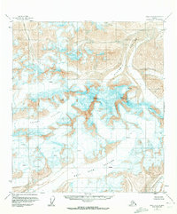
1951 Map of Healy C-1
USGS Topo · Published 1972About this map
Mt Deborah and Hess Mountain dominate the skyline of this high-altitude landscape in the Alaska Range. The 1951 field annotations reveal a massive network of moving ice, including the expansive Gillam Glacier and Yanert Glacier. The topographic survey captures these ice fields before significant late-century recession, detailing specific crevasses and the drainage patterns that feed into the West Fork Glacier and Susitna Glacier. Mapping based on aerial photography from the mid-1950s provides a precise record of these unsurveyed and unmarked lands as they existed in the early post-war era, documenting a wilderness defined by its elevation and glacial flow rather than human settlement or infrastructure.
Find a feature on this map
7 named features on this map. Tap any name to fly to it.
Don’t see what you’re looking for? This feature index may not catch every label — zoom into the map to look around manually.
Map Details
Editions of this 1951 Healy C-1 Map
3 editions found
Other maps of this area

1949 · Healy B-2
USGS Topo · 1:63,360

1949 · Healy D-1
USGS Topo · 1:63,360

1950 · Mount Hayes
USGS Topo · 1:250,000

1950 · Mount Hayes D-6
USGS Topo · 1:63,360

1950 · Healy B-1
USGS Topo · 1:63,360

1951 · Healy
USGS Topo · 1:250,000

1951 · Mount Hayes
USGS Topo · 1:250,000

1951 · Mount Hayes B-6
USGS Topo · 1:63,360

1951 · Healy C-1
USGS Topo · 1:63,360

1951 · Healy C-2
USGS Topo · 1:63,360