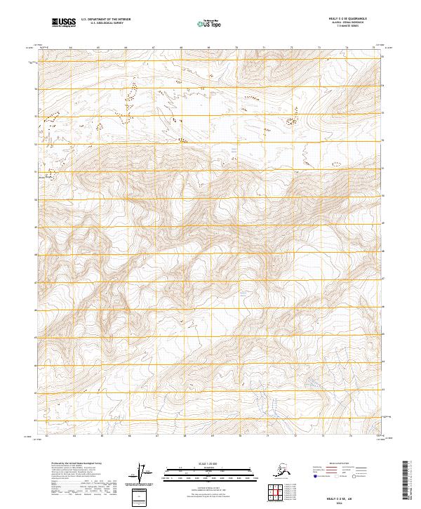
2024 Map of Healy C-2 SE
USGS Topo · Published 2024About this map
The Alaska Range dominates this quadrangle, defining a high-altitude landscape where massive ice fields shape the drainage patterns of the interior. Two primary glacial systems are documented here: the Yanert Glacier in the north and the Nenana Glacier to the south. These glaciers serve as the headwaters for significant regional watercourses, with their movements recorded through the detailed contour lines and elevation data captured by the U.S. Geological Survey. The map reflects the uninhabited and glaciated nature of the Denali Borough, focusing on the topographic relationship between these ice masses and the surrounding peaks of the range. Surveying boundaries such as t15s r1w and t15s r1e provide a geographic grid for this wilderness area, illustrating how the public land survey system is applied even to the most inaccessible sections of the Alaskan interior.
Find a feature on this map
7 named features on this map. Tap any name to fly to it.
Don’t see what you’re looking for? This feature index may not catch every label — zoom into the map to look around manually.
Map Details
Editions of this 2024 Healy C-2 SE Map
This is the sole edition of this map. No revisions or reprints were ever made.
Other maps of this area

1949 · Healy B-2
USGS Topo · 1:63,360

1950 · Healy B-1
USGS Topo · 1:63,360

1951 · Healy
USGS Topo · 1:250,000

1951 · Healy C-1
USGS Topo · 1:63,360

1951 · Healy C-2
USGS Topo · 1:63,360

1952 · Healy B-1
USGS Topo · 1:63,360

1952 · Healy B-2
USGS Topo · 1:63,360

1956 · Healy
USGS Topo · 1:250,000
2016 · Healy C-1 SW
USGS Topo · 1:25,000
2016 · Healy B-1 NW
USGS Topo · 1:25,000