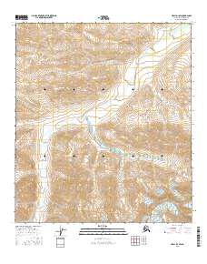
2016 Map of Healy D-1 SW
USGS Topo · Published 2016About this map
Alaska Range foothills dominate this high-altitude terrain in the Tanana Valley watershed. The drainage system is defined by the West Fork Little Delta River, which cuts a broad, braided path through the central and northern sections of the quadrangle. As the river moves through this interior Alaska landscape, it is fed by several smaller tributaries including Slate Cr in the northeast and the appropriately named Forgotten Cr tucked into the central hills. The map illustrates the transition from high ridgelines down to the active gravel bars and alluvial plains of the river valley. The lack of road infrastructure or permanent settlements underscores the primary character of this region as a wilderness corridor defined by glacial runoff and the shifting channels of the Little Delta river system.
Find a feature on this map
8 named features on this map. Tap any name to fly to it.
Don’t see what you’re looking for? This feature index may not catch every label — zoom into the map to look around manually.
Map Details
Editions of this 2016 Healy D-1 SW Map
This is the sole edition of this map. No revisions or reprints were ever made.
Other maps of this area

1949 · Healy D-1
USGS Topo · 1:63,360

1951 · Healy
USGS Topo · 1:250,000

1951 · Healy C-1
USGS Topo · 1:63,360

1951 · Healy C-2
USGS Topo · 1:63,360
1951 · Healy D-2
USGS Topo · 1:63,360
1952 · Healy D-1
USGS Topo · 1:63,360
1952 · Healy D-2
USGS Topo · 1:63,360

1956 · Healy
USGS Topo · 1:250,000
2016 · Healy D-2 NE
USGS Topo · 1:25,000
2016 · Healy C-1 NW
USGS Topo · 1:25,000