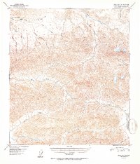
1952 Map of Healy D-3
USGS Topo · Published 1952About this map
Totatlanika River and the Wood River dominate this interior landscape, which was documented using aerial photography in the late 1940s. The area is defined by a dense network of watercourses, many with names suggesting a history of prospecting, such as All Gold Creek, Last Chance Creek, and Gold King Creek. These tributaries flow through high elevations, marked by landmarks like Keevy Peak and the prominent Needle Rock. A few isolated Cabin sites are the only indicators of human habitation in this expanse of the Alaska-Fourth Judicial Division, likely serving as seasonal shelters for those navigating the drainages of Healy Creek or Cody Creek. The map provides a clear look at the drainage patterns before significant modern development altered the wilderness character of the region.
Find a feature on this map
20 named features on this map. Tap any name to fly to it.
Don’t see what you’re looking for? This feature index may not catch every label — zoom into the map to look around manually.
Map Details
Editions of this 1952 Healy D-3 Map
2 editions found
Other maps of this area

1949 · Healy C-3
USGS Topo · 1:63,360

1949 · Fairbanks A-2
USGS Topo · 1:63,360

1950 · Fairbanks
USGS Topo · 1:250,000

1950 · Healy D-4
USGS Topo · 1:63,360

1950 · Healy C-4
USGS Topo · 1:63,360

1950 · Fairbanks A-4
USGS Topo · 1:63,360

1950 · Fairbanks A-3
USGS Topo · 1:63,360

1950 · Healy D-3
USGS Topo · 1:63,360

1951 · Healy
USGS Topo · 1:250,000

1951 · Fairbanks
USGS Topo · 1:250,000