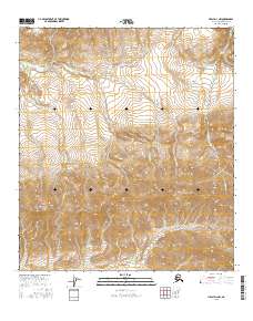
2016 Map of Healy D-3 NW
USGS Topo · Published 2016About this map
Usibelli Peak and Mt Lathrop dominate the high-elevation landscape of this remote Interior Alaska terrain within the Denali Borough. The drainage patterns revealed here show a network of creeks feeding the larger Totatlanika River as it flows northward through the foothills. Small watercourses with evocative names like All Gold Cr, Surprise Cr, and Shovel Cr suggest the prospecting history and geological character of this wilderness area.
Find a feature on this map
17 named features on this map. Tap any name to fly to it.
Don’t see what you’re looking for? This feature index may not catch every label — zoom into the map to look around manually.
Map Details
Editions of this 2016 Healy D-3 NW Map
This is the sole edition of this map. No revisions or reprints were ever made.
Other maps of this area

1950 · Fairbanks
USGS Topo · 1:250,000

1950 · Healy D-4
USGS Topo · 1:63,360

1950 · Fairbanks A-4
USGS Topo · 1:63,360

1950 · Fairbanks A-3
USGS Topo · 1:63,360

1950 · Healy D-3
USGS Topo · 1:63,360

1951 · Healy
USGS Topo · 1:250,000

1951 · Fairbanks
USGS Topo · 1:250,000
1952 · Fairbanks A-4
USGS Topo · 1:63,360
1952 · Healy D-3
USGS Topo · 1:63,360
1952 · Fairbanks A-3
USGS Topo · 1:63,360