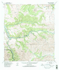
1950 Map of Healy D-4
USGS Topo · Published 1997About this map
Industrial mining operations and mountain peaks define the landscape around Healy in the mid-20th century. The Alaska Railroad follows the path of the Nenana River, providing a critical transportation link for the coal mining communities of Suntrana and Usibelli. Evidence of heavy extraction is visible along Healy Creek, where multiple Strip Mines and the Cripple Creek Mine are situated between the towering heights of Jumbo Dome and Dora Peak.
Find a feature on this map
49 named features on this map. Tap any name to fly to it.
Don’t see what you’re looking for? This feature index may not catch every label — zoom into the map to look around manually.
Map Details
Editions of this 1950 Healy D-4 Map
4 editions found
Other maps of this area

1949 · Healy C-3
USGS Topo · 1:63,360

1950 · Fairbanks
USGS Topo · 1:250,000

1950 · Fairbanks A-5
USGS Topo · 1:63,360

1950 · Healy D-4
USGS Topo · 1:63,360

1950 · Healy C-4
USGS Topo · 1:63,360

1950 · Fairbanks A-4
USGS Topo · 1:63,360

1950 · Fairbanks A-3
USGS Topo · 1:63,360

1950 · Healy D-3
USGS Topo · 1:63,360

1951 · Healy
USGS Topo · 1:250,000

1951 · Fairbanks
USGS Topo · 1:250,000