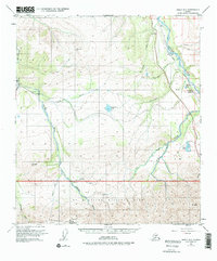
1951 Map of Healy D-5
USGS Topo · Published 1975About this map
Mt McKinley National Park dominates the southern reaches of this landscape, where the Savage River and Sanctuary River flow north out of high-elevation ridges. The northern half of the survey reveals a frontier infrastructure focused on resource extraction and transit, centered around the settlement of Lignite. Here, the Alaska Railroad follows the winding path of the Nenana River, supported by local industry including a Mine and a Tramway. The map captures the remote character of the interior at mid-century, documented by the presence of a Ranger Cabin along Sunday Creek and a Landing Strip further west. Natural landmarks like Mount Margaret and Primrose Ridge frame the drainage basins of Fish Creek and Panguingue Creek, illustrating the complex network of waterways that defined travel and boundary lines in this part of the Alaska Territory.
Find a feature on this map
33 named features on this map. Tap any name to fly to it.
Don’t see what you’re looking for? This feature index may not catch every label — zoom into the map to look around manually.
Map Details
Editions of this 1951 Healy D-5 Map
4 editions found
Other maps of this area

1950 · Fairbanks
USGS Topo · 1:250,000

1950 · Fairbanks A-5
USGS Topo · 1:63,360

1950 · Healy D-4
USGS Topo · 1:63,360

1950 · Healy C-4
USGS Topo · 1:63,360

1950 · Fairbanks A-4
USGS Topo · 1:63,360

1951 · Healy
USGS Topo · 1:250,000

1951 · Fairbanks
USGS Topo · 1:250,000

1951 · Fairbanks A-5
USGS Topo · 1:63,360

1951 · Healy D-6
USGS Topo · 1:63,360

1951 · Healy D-5
USGS Topo · 1:63,360