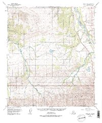
1951 Map of Healy D-5
USGS Topo · Published 1975About this map
Mount McKinley National Park dominates the southern landscape of this 1951 survey, where the northern slopes of Primrose Ridge and Mount Margaret give way to a complex network of glacial rivers. The industrial and transit corridor follows the Nenana River along the eastern edge, anchored by the Alaska Railroad and the small settlement of Lignite. This area highlights the transition from the high interior peaks to the subarctic lowlands, featuring several large water bodies such as Eightmile Lake and Otto Lake. The interior is marked by a remote Ranger Cabin along the Savage River, indicating the early management and patrol routes of the park before modern development. Traces of early resource exploration appear near the railroad, including a Mine and a Landing Strip near the confluence of Fish Creek.
Find a feature on this map
28 named features on this map. Tap any name to fly to it.
Don’t see what you’re looking for? This feature index may not catch every label — zoom into the map to look around manually.
Map Details
Editions of this 1951 Healy D-5 Map
4 editions found
Other maps of this area

1950 · Fairbanks
USGS Topo · 1:250,000

1950 · Fairbanks A-5
USGS Topo · 1:63,360

1950 · Healy D-4
USGS Topo · 1:63,360

1950 · Healy C-4
USGS Topo · 1:63,360

1950 · Fairbanks A-4
USGS Topo · 1:63,360

1951 · Healy
USGS Topo · 1:250,000

1951 · Fairbanks
USGS Topo · 1:250,000

1951 · Fairbanks A-5
USGS Topo · 1:63,360

1951 · Healy D-6
USGS Topo · 1:63,360

1951 · Healy D-5
USGS Topo · 1:63,360