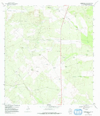
1967 Map of Hebbronville NW
USGS Topo · Published 1991About this map
Trevino Ranch and Barronena Ranch anchor this 1967 portrait of Duval County, where the brush country landscape is defined by the vital search for water. The terrain is marked by an extensive network of family-named windmills and stock tanks, such as the Estella Windmill, Lone Star Windmill, and Rogers Windmill, which facilitated ranching across the semi-arid plains. Several ephemeral watercourses, including Santonino Creek and Arroyo de los Angeles Creek, carve through the Mesquite-covered ground, while numerous Oil Wells and a Gravel Pit indicate the mid-century industrial extraction efforts in the region. This survey captures a specific era of South Texas land use, showing the intersection of traditional ranching outposts and modern resource development.
Find a feature on this map
31 named features on this map. Tap any name to fly to it.
Don’t see what you’re looking for? This feature index may not catch every label — zoom into the map to look around manually.
Map Details
Editions of this 1967 Hebbronville NW Map
2 editions found
Other maps of this area

1939 · Bruni
USGS Topo · 1:62,500

1956 · Laredo
USGS Topo · 1:250,000

1967 · Hebbronville SE
USGS Topo · 1:24,000

1967 · Parrilla Creek SE
USGS Topo · 1:24,000

1967 · Realitos
USGS Topo · 1:24,000

1967 · Hebbronville NW
USGS Topo · 1:24,000

1967 · Hebbronville
USGS Topo · 1:24,000

1968 · Parrilla Creek SW
USGS Topo · 1:24,000

1968 · San Pablo
USGS Topo · 1:24,000

1972 · Bruni SE
USGS Topo · 1:24,000