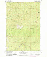
1966 Map of Hemlock Butte
USGS Topo · Published 1985About this map
Clearwater National Forest land dominates this mid-1960s survey, illustrating a landscape defined by industrial extraction and high-altitude terrain. The presence of the Pistol Grip Mine, Red Cloud Mine, and Pioneer Mine points to the area's mineral prospects, while a network of pack trails serves as the primary infrastructure for traversing the steep ridges and gulches. Named for the prominent Hemlock Butte and its adjacent Hemlock Creek, the topography is carved by a complex drainage system including the Musselshell and Orofino watersheds. Evidence of human activity is clustered along these watercourses and ridgelines, from the Belle Creek Campground to the high passes at French Saddle and Lost Hat Saddle. This edition provides a detailed look at the border between Clearwater and Idaho counties, capturing the wilderness character of the region before modern development.
Find a feature on this map
48 named features on this map. Tap any name to fly to it.
Don’t see what you’re looking for? This feature index may not catch every label — zoom into the map to look around manually.
Map Details
Editions of this 1966 Hemlock Butte Map
2 editions found
Other maps of this area

1923 · Washington Creek
USGS Topo · 1:125,000

1924 · Weippe
USGS Topo · 1:125,000

1938 · Headquarters
USGS Topo · 1:48,000

1944 · Headquarters
USGS Topo · 1:62,500

1956 · Hamilton
USGS Topo · 1:250,000

1959 · Hamilton
USGS Topo · 1:250,000

1960 · Hamilton
USGS Topo · 1:250,000

1964 · Hamilton
USGS Topo · 1:250,000
1965 · Larch Butte
USGS Topo · 1:24,000

1965 · French Mountain
USGS Topo · 1:24,000